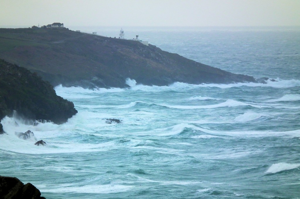
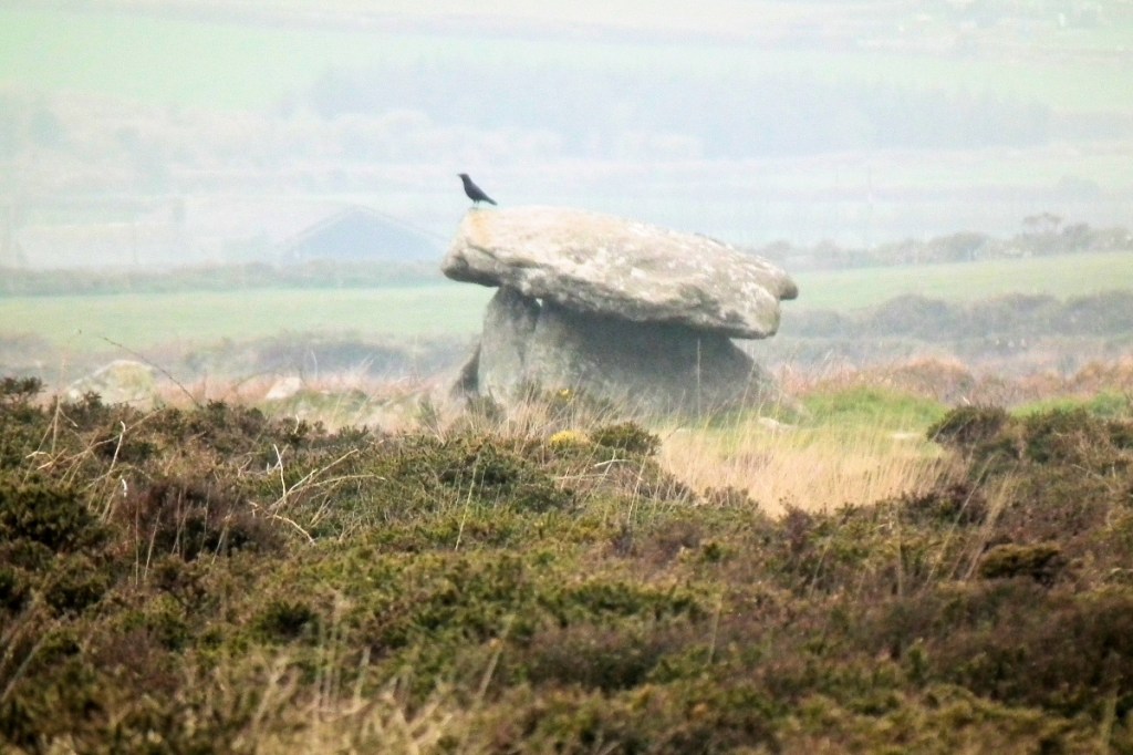
They came. And they went. They went scorching along the south coast of Britain toward the Netherlands. The storm gods, that is. It was a right old holy hoolie, a demonstration of the Power and the Glory for everyone in Cornwall to hide away from. And we did.
It’s one of those situations where you just have to huddle down, say your prayers and wait. One of those situations where even proudly hubristic secular rationalists start saying a prayer, just in case. You have to wait until it’s over, because it’s no longer in your power to do anything much else.
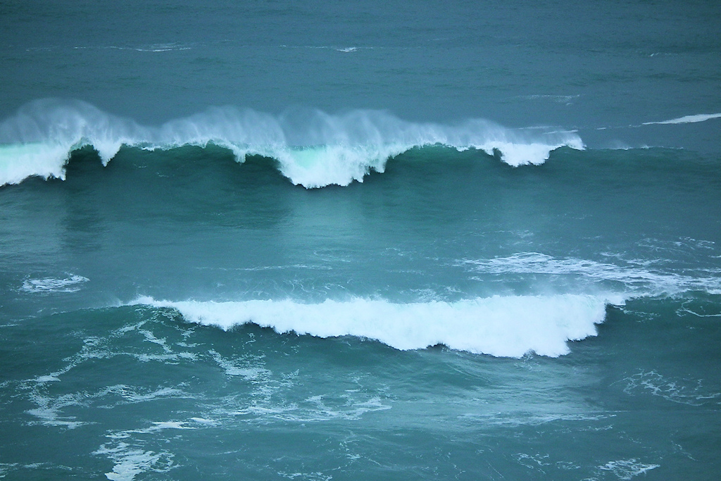
The winds were resolute, firm and consistent, not blustery or tricksy – they were forceful, merciless and thoroughly unrestrained. This was what in capitalism they call a hostile take-over. No consultation, no regard for human rights, no compassion: just the energy and might of a full-on Atlantic storm, a gift of the gods to remind us how small we are and how easy it is to wipe us out and dispose of us, if Nature so chooses.
Too often, we arrogant, self-centred, comfort-addicted humans forget this. It’s not that difficult for Nature to blink or cough, sending us beetling off to Heaven in our thousands, for the angels to sort out. Well, I’m heading that way anyway, sometime soon, and if the weather gods wish to take me today, getting in there first before the cancer gods get me, then what a way to go. I won’t complain. You have to get to Heaven somehow, after all, and in this there is no choice except for timing and method.
But it was okay. The lights went off and I sat in bed, reading in candlelight a novel about the Dreyfus Affair of 1890s France – as it happens, topically, a prime example of institutional anti-Semitism if ever there was one. Then I dropped off to sleep, with 100mph winds screeching over my little cabin, The Lookout.
They were coming from the northwest, and a hill stands there behind the farm, sheltering us from the Atlantic vastness, 3,000 miles of it, and it was okay. Had the winds been coming from the south, as in some of the storms of 2014, there would have been trouble on the farm. We were okay, but across Cornwall a lot of people were not, and many trees lost their lives. I found myself wondering what small birds do in super-storms like this, like the tits, dunnets and the robin who patronise the feeder outside my door.
Anyhow, I’m a survivor, and programmed up for it. Well, much of the time. The main dangers I have faced in my life have been from humans – control-freaky Israeli soldiers, nervy Palestinian freedom fighters, gritty ISIS terrorists and crack-addled Nigerian criminals – and the force of Nature has a more comforting side to it.
It is mighty, threatening and decisive, administering justice in a remarkably even-handed way and singling out all those things you’d failed to notice or do anything about during calmer times, making them fly. But it speaks the words of The Ultimate, and no one can argue with that – even The Donald, living as he does in a hurricane corridor called Florida, the land of the flowers, who badly needs to realise that he is not God and never will be.
But human dangers are another matter, and with them you’re dealing with a different, more capricious and regrettable kind of randomness.
When I woke up there was no power or water. Jon, the farmer, was clearing up the mess in the farmyard – the roof of his woodshed had radically repositioned itself. There was no phone signal, so a neighbour had driven to where there was a signal, finding out that we might, with luck, expect power back Friday afternoon. It took until Saturday afternoon.
Well and good. Except there’s one problem. Why is it that the power always returns just at that moment when you’re beginning to enjoy the calm and the candlelight?
But I do have a woodstove, and it soon was alight. There was the light of a lovely golden dawn over the valley, exhibiting another kind of Power and Glory from that of the night before. The birds were very quiet, probably a bit groggy after a long, trying midwinter night. There was no sign of the flight of geese who pass over the farm in the morning, hooting and croaking to the Void as if sadly lamenting the insecurity and non-attachment that migrating animals have to accept. They’d probably come from Greenland, Iceland or Norway, now wondering whether they might have been better to stay there.
So I pottered around. The worst that can happen is that the food in my freezer defrosts. No bombs are falling, and no earthquake-aftershocks are to be expected. Before long a saucepan was on the woodstove, warming up for the first pot of tea. I stumbled down into the farmyard and along the track to check a neighbour – yes, she was okay and huddling in bed with her dog. I came back, making my walking-stick work hard, poured the tea and read more of my book. Then I rooted around in the cupboards and found a Tilda pack of lemon and herb rice – and that went on the stove too, with some grapes thrown in.
One of the best meals I’ve ever had was during an Israeli lockdown on the West Bank. People in the rich world, all neurotic about our loss of freedoms, complained loudly during the Covid lockdowns, but with an Israeli lockdown, well, if you go out, you risk getting shot – it’s quite simple. Israeli troops are trained to shoot first and think later. In circumstances such as this, a kind of culinary gallows humour takes over and, using what you have in the cupboards, some amazing feasts can be had.
This is partially a perceptual issue. At a Palestinian refugee quarter outside Damascus, since I was a European with some diplomatic skills, I went out to see if I could find some food for the family I was staying with. We outsiders sometimes could get to places and negotiate things that others could not – though it would depend, of course, on the mood and values of any gun-toting man you met along the way, and whether they spoke English, German, Swedish or French. My ageing, sixty-something brains were having difficulty absorbing Arabic.
I usually managed to convince them I was a decent chap. Arabs are good at reading your body-language. Anyway, it was my lucky day and I came back with a shoulder-bag of bread – including, strangely, a plastic-wrapped pack of German pumpernickel. We had a true feast – of bread, with a few old, chewy olives thrown in. And, believe me, it was a wondrous and happy feast. Palestinians are well used to this kind of thing, though they have one weak point: they go through big coffee-withdrawal problems during lockdowns and hard times.
People often ask me what I used to do in Palestine and Syria. Well, I’ve done three books and an audiobook on the matter (links below), but the short answer is, things like this. Such as finding bread for a family to eat because, in the circumstances, I had the capacity to do so. It’s a small matter, finding food, but a meal can have a big effect on people’s mood and welfare. And you get to eat something too.
So a Cornish winter hoolie, well, it takes me back to that alert, resigned, improvisational, ready-to-run state that you get into when stuck in an emergency. You’re out of control of your fate, yet strangely in control too – though it’s necessary to leave the fear until later. In a funny sort of way it brings out the best in me. Comfortably normal regularity is not my forte, as my former partners can easily testify.
My computer battery is running out and I’ve said enough. I’ve been churning out verbiage for a whole lifetime, so no more is necessary. And, as usual, I’ve forgotten my tea and it has gone cold. So I’ll put my mug on the woodstove and, lo behold, in a few minutes it’ll be warm again. What simple delight can be found in small mercies.
And, as Arabs often say, Allahu Akbar, God is Great. Life is a wondrous thing. It’s a gift that’s worth cherishing while we have it. As something of an expert in other worlds and their characteristics, I can safely inform you that the tea on Earth is the best in the whole Universe. If you don’t believe me, your turn will come to find out.
However, compensations are available in Heaven. It’s a cool place to be, so don’t worry about the tea or other such things. Other things matter there. But just make sure that, when your own time comes, you’ve had enough of the experiences of this world to have, in another sense, truly had enough of them.
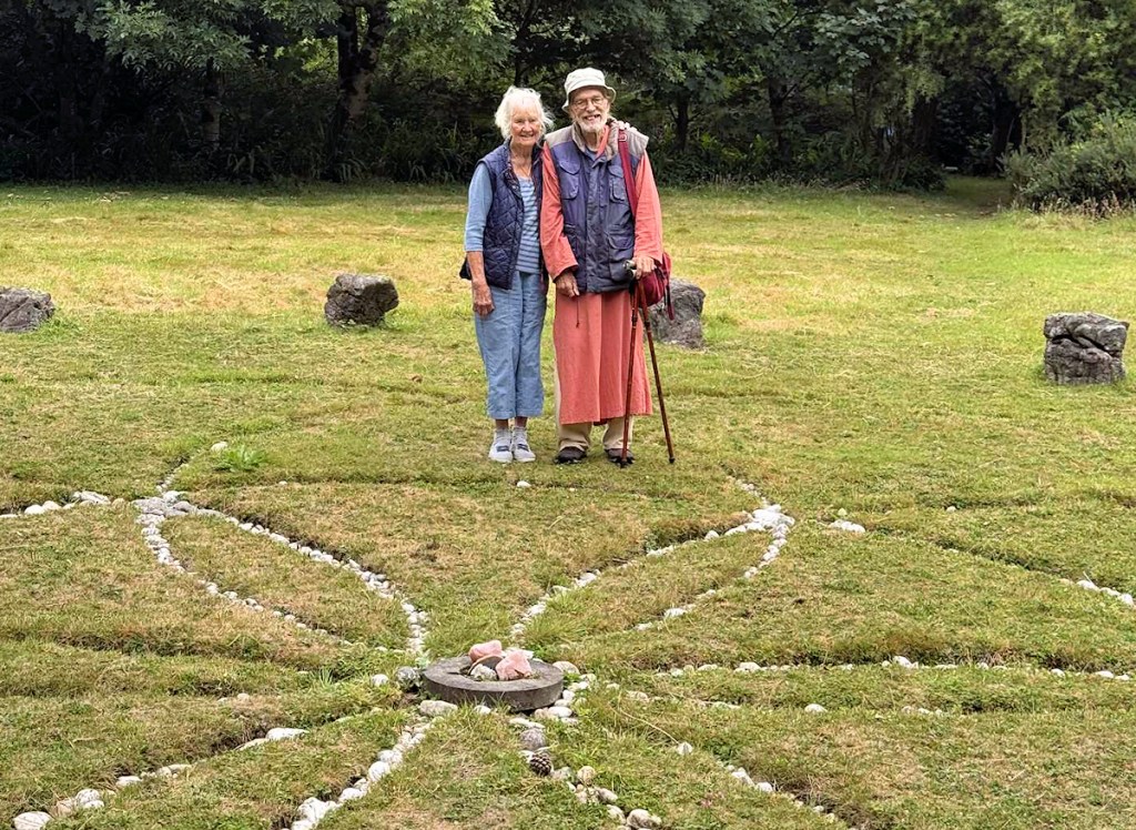
A talk given by Ba Miller and Palden Jenkins, sharing our thoughts, anecdotes and experiences in dowsing, geomancy, earth mysteries and consciousness.
It happened on Sunday afternoon, 7th December 2025, at The Hive in Penzance, Cornwall, and it’s for you.
It’s ‘limited edition’, with love from both of us. Gratitude to the organiser, Rachel Smart, presenter Lucy Cooper, songstress Lyndz Liquidlight and Hive hostess Maria Stay.
Ba Miller was involved with Hamish Miller and Paul Broadhurst in their research into the Michael Line and the Apollo Line, as detailed in their books ‘The Sun and the Serpent’ and ‘Dance of the Dragon’. Palden Jenkins is an astrologer and geomancer, author of ‘Shining Land’ and of www.ancientpenwith.org
It’s two hours. No charge, no strings. Hope you enjoy it.
This might interest those of you who are interested!
These are two chapters from my book about Penwith’s ancient sites, called Shining Land – except these two are about the whole of Cornwall.
From an alternative archaeologist’s viewpoint. With a few speculations thrown in for consideration. Food for thought. With love from the far end in (currently) wind-blown Penwith.
It’s a 20ish minute read (goes well with a mug of tea). I might do an audio version sometime – you never know.
A Bronze Age gathering place in West Penwith, Cornwall Palden Jenkins, June 2025
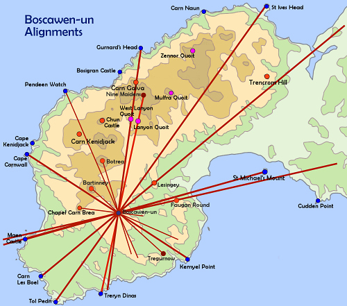
Recently I was at Caer Brân (pronounced Ker Brayne) on a Belerion Project field trip. Nowadays partially disabled, I hadn’t been there for years, even though, when I look out of my window from my desk, it’s on the ridge over the valley, less than a mile away. So I gaze at it a lot.
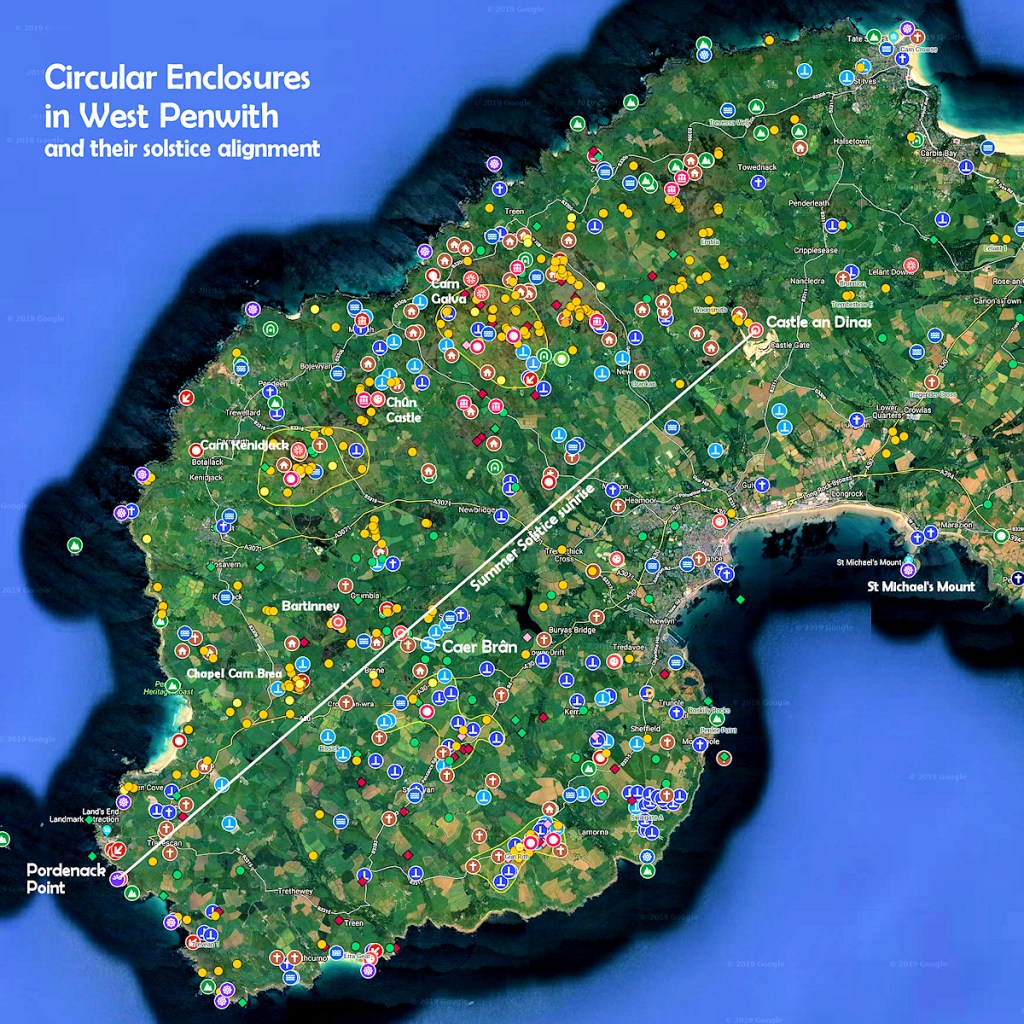
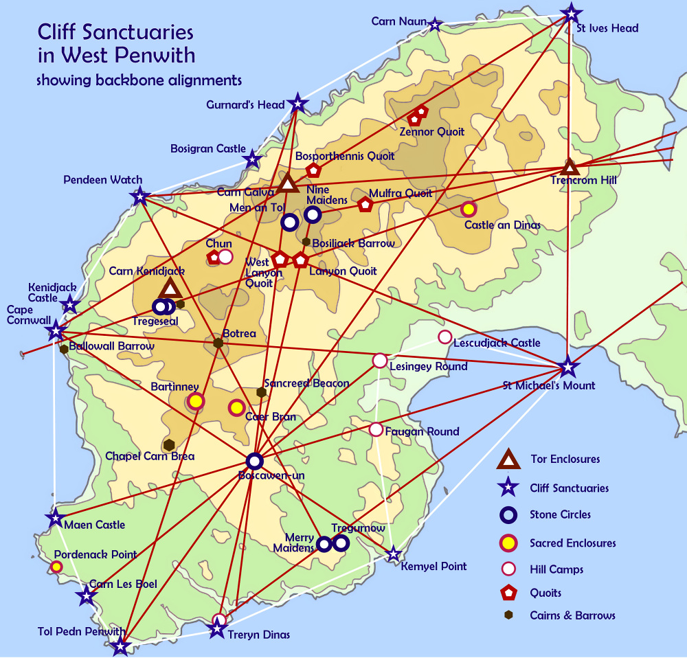
In former years I had come to the idea that, in the Mid-Bronze Age, Caer Brân served as a kind of parliament site for the whole of Penwith. This came to me after news came out some years ago about a circular enclosure, found using LIDAR scanning, on the cliffs at Pordenack Point, just south of Land’s End. This revealed something: Pordenack, Caer Brân and Castle an Dinas, three circular enclosures, were built in a straight line, oriented to the summer solstice sunrise.
This suddenly gave these three sites a lot more significance than had been seen previously.
However, if we take a line from the centre of the Pordenack clifftop enclosure to the centre of Castle an Dinas, it passes through Caer Brân though not accurately through its centre. It passes across the southeast side of Caer Brân, though within the enclosure. I’m not sure whether there is any meaning to that, but these details are worth observing.
At ancient sites, the main thing I do is a kind of psychic archaeology. That’s not as esoteric or complex as it sounds. All I do is sit there, relax, give it time, and I let feelings and ideas come up. It’s not a matter of trying, but of allowing. Often I use a pendulum, which helps engage both thinking and intuition. I do this in two ways, flipping between them: I use a pendulum while doing ‘intuitive free-thinking’ – it indicates when I’m ‘on track’ or ‘off track’ – and also I ask specific questions about details and dates, seeking a Yes/No answer. I note it all down or speak what’s coming up into a sound-recorder.
As an historian, I’m attentive to historic plausibility before jumping to conclusions arising from these ‘subjective’ researches. Mistakes can often be made in the interpretation of impressions and ideas, more than in their initial psycho-intuitive reception. It’s important to avoid allowing existing ideas, knowledge and preferences to shade and bias such findings, though it’s important afterwards to see how new insights fit with foregoing ones – if indeed they do.
If they don’t somehow fit, then the observation might either be incorrect or something is yet to be discovered that will make sense of it. In one case I had to wait twenty years. You get surprises. Findings might at first make no sense, or no concrete or logical evidence backs them up, but later on things can fall into place. So for much of the time they remain working hypotheses, not facts. One trick is to consider their plausibility and whether they shed light on anything else. Some archaeological findings suffer this problem, or their interpretation is conjectural – as is the case with a few seemingly authoritative statements on the signboard below Caer Brân (more below).
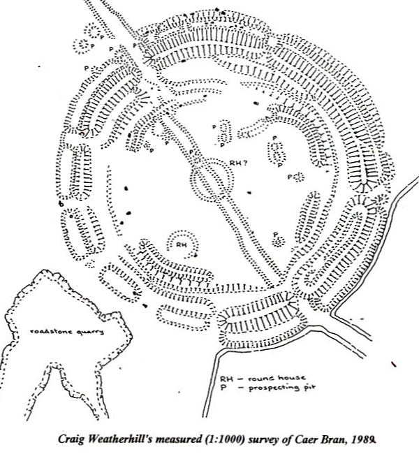
Craig Weatherhill’s survey of Caer Brân
Here are some findings from my recent visit to Caer Brân.
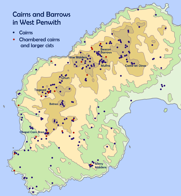
It seems to me that it is not the inherent earth energy of this place that matters, as is the case at a stone circle. There isn’t the same sense of energy here. It seems that the landscape positioning of Caer Brân matters more: there’s a strong visual connection with other key sites in Penwith and beyond, including Scilly, the Lizard and Carn Brea near Redruth. It has a wide, thirty-mile panorama.
Very noticeable are the sightlines from Caer Brân to Neolithic sites which, at the time of Caer Brân’s building, would themselves have been regarded as ancient – about 1,800 years older than Caer Brân.
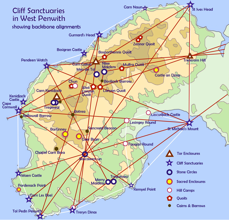
All of Penwith’s Neolithic sites are visible except Trencrom Hill. Carn Kenidjack and Carn Galva poke above the horizon as if placed there by an enormous geological chess-player’s hand; Carn Brea is distant yet prominent; St Michael’s Mount sits resplendently down in Mount’s Bay. The Isles of Scilly hover in the gap between Chapel Carn Brea and Bartinney Castle. So visual connectedness with other sites was clearly important. Caer Brân is not prominently visible from these sites – it’s a one-way visibility.
Apart from sightlines, it has several alignments (leylines) associating it with other ancient sites, yet these are largely rather unspectacular except for two. Alignments don’t seem to be a dominant factor here – sightlines are more important. (Click for an alignments map of Penwith.)
One alignment (83) goes from the summit cairn on nearby Chapel Carn Brea through Caer Brân’s SW edge to St Erth church (on an Iron Age round that might be older) and finally it heads for the Neolithic tor of Carn Brea.
The other (199) goes from Cape Cornwall to Caer Brân, then to the Blind Fiddler menhir and Kerris Round, then over Mount’s Bay to Predannack Head, a clifftop site on the Lizard that feels a bit like a geomantic control tower – it’s worth a visit. The first alignment links two Neolithic hills and the second links two major cliff sanctuaries.
Caer Brân doesn’t feel like a high-energy place, though it does have atmosphere. However, as a former gathering place, it feels to me as if it misses the human attention and ‘hwyl’ that it once witnessed and hosted. (Hwyl is Welsh for fun and stirring, special experiences).
Archaeologists commonly use the term ‘ceremonial’ for sites like this, but this is inaccurate. This was a gathering place, a people place. The enclosure uphill on Bartinney Castle was clearly ceremonial and magical, but I believe Caer Brân was mainly social in character and purpose.
These two adjacent sites, hardly a mile apart, formed a pair – Bartinney more spiritual and Caer Brân more worldly. During their moots, people assembled at Caer Brân probably trooped up to Bartinney for the spiritual high point of their gatherings, or to seal the deal. Tradition has it that inside the enclosure on Bartinney evil cannot touch you.
Sancreed Beacon, Caer Brân and Bartinney, arrayed along a ridge, were part of a local landscape temple also comprising Botrea Hill, Chapel Carn Brea and Boscawen-ûn stone circle. This ridge seems to act as a kind of fulcrum for the whole of Penwith, and Chapel Carn Brea, Botrea Hill and Boscawen-ûn anchor and stabilise it on either side.
This is all about a geomantic quality we could call ‘perceptual centrality’ – the feeling that you’re standing at the centre of everything. This is common at many ancient sites: a subtle sense of emphasised hereness and nowness that is one of their key psycho-spiritual effects. It seems odd that Boscawen-ûn acts as a peripheral anchor to this string of three hills. Yet this is how it seems at Caer Brân, standing at the centre of its own psycho-geographic gravity-field. Yet at Boscawen-ûn, sitting at the centre of its own perceptual gravity field, it seems as if Caer Brân and Chapel Carn Brea are peripheral appendages to it.
Each major site in Penwith is a gravity-centre of psycho-geographic experience. In one sense this is a perceptual matter, while in another it’s a very real, a repeatable experience shared by many people. In a pre-literate society with no maps or aerial photos, people were psychologically part of their world and it was part of them. They perceived their world differently to us.
This was particularly so in the Neolithic. As the Bronze Age progressed, man-made landscape expanded in extent and people started developing more of a sense of mastery of nature rather than of being guests in it. Even so, their ancient sites were stretched over and fitted to nature and the landscape without imposing on them. Bronzies’ nature-interventions were largely sympathetic. Rampant resource exploitation came later in history.
On the signboard downhill from Caer Brân I think they got a few details wrong. They associate Caer Brân with Carn Euny, a nearby ancient settlement, suggesting that the villagers had built and used it. That’s logical, though I think it is incorrect.
The impression I get is that Caer Brân was a Penwith-wide social-infrastructure project. People were called up from all over Penwith to build it. It was to be a neutral space, owned or hosted by no individual clan. It was to act as a meeting place for all of the Penwithian clans, or their representatives. It’s possible there were around ten clans.
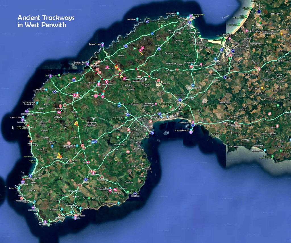
Its geographic centrality in Penwith and its location at the crossroads of two major ancient trackways are clues suggesting this (see trackway map below), together with the solstice alignment of the three circular sites. So while Carn Euny looks like a logical ‘owner’ of Caer Brân, I don’t think this was so. Neither was Castle an Dinas, Penwith’s other big gathering site, controlled by one clan. It is likely it was built around the same time as Caer Brân, and that they were built with different purposes in mind.
Using a pendulum, I asked how long it took to build Caer Brân: I got ‘two summers’. That was surprising: I expected longer (such as five years). This would have involved quite a mobilisation of available hands and backup support, including supplying tools and food and maintaining life’s normal demands back home. They wanted to get the job done quickly.
Perhaps there was an urgent need. Perhaps they had reached a kind of political juncture in Penwith, where a pressing need came up to reorganise things, reflecting emergent needs and realities. Or perhaps there was a generational shift in a time of social change and population growth, necessitating the building of new gathering places.
The signboard got one thing right: the ‘ring cairns’ inside Caer Brân are older than the enclosure. I date-dowsed them to the 2200s BCE, while the enclosure came 400ish years later in the 1830s. Except that the ‘ring cairns’ were roundhuts. The one in the centre of Caer Brân gave me the sense of a Hopi Kiva, a place for focused magical-spiritual work – I got the image of a crucible. It was placed there not because of a major energy-vortex at that place, but because of its visual, almost geometric connections with other places in the wider landscape.
I found that three main gatherings were held each year: on the fullmoons around Imbolc and Lughnasa, and another in early December. I asked why this third one was not at winter solstice and got a straight reply, ‘Everyone wanted to be at home then’. Well, indeed. And since fullmoons light up the night, often marking shifts in the season or in weather patterns, the Bronzies were probably not as concerned with exact cross-quarter days as with the fullmoons near to them. The moon provided no-cost solar-powered lighting. And a taste of magic.
The climate was a bit warmer then, less windy, stormy and Atlantic-dominated than it is now. This changed around the 1200s at the end of the Megalithic period – the jetstream moved south, bringing more wind, rain and changeable weather. It made sense in the Neolithic and Bronze Ages to be on panoramic hilltops like Caer Brân. In the Late Bronze Age after 1200ish, people moved downhill, abandoning or sidelining many of the megalithic sites.
Date dowsing suggests that Caer Brân was built in the 1830s BCE and was in use until the 1330s. This is longer than archaeologists reckon – it’s that signboard again. They give Caer Brân a short active life, on the basis that a gap in the ‘ramparts’ in the southwest of the enclosure represents an unfinished segment, and that, ergo, the enclosure was abandoned at the end of its construction.
This seemingly logical conclusion seems to me to be flimsy. Abandoning a project that is 95% complete is a bit strange. The abandonment idea was probably adopted in the days when archaeologists saw Caer Brân as a ‘hillfort’ built for defensive purposes. But, nationwide, the majority of hillforts were not built for this – especially in Penwith, where there are no signs of prehistoric conflict. There is no evidence of outright abandonment of Caer Brân either – it’s a best guess. No, I think that gap was deliberate. However, I cannot figure out why it was built so, and this question needs more work.
While we’re here, it’s worth observing that the second roundhut toward the southwest edge of the enclosure, marked on Craig Weatherhill’s survey, is also at the crossing point of four local alignments and close to the Pordenack to Castle an Dinas solar alignment, which crosses Caer Brân off-centre. From this we can surmise that this was probably no ordinary residential roundhut, instead having some sort of magical meaning. If alignments pass through a roundhut, in my experience it is likely that it was not residential in purpose.
In a moment of vision, I saw twentyish elders sitting in an arc, presiding over long discussions. I feel this was the political meeting place in Penwith. What came to me was this: it took until 1800 BCE to build Caer Brân because only by that date had the newly-colonised south of Penwith really been fully established. The south was colonised in the Bronze Age as population grew and bronze tools for clearing trees and land came into common use, probably around 2200-2000 BCE. A gradual southward population move would follow, shifting the balance of population. Until then the traditional power centre was around Chûn, Carn Galva and Zennor Hill in the north.
So by 1800 the centre of gravity had shifted south. The Boscawen-ûn and Merry Maidens stone circle complexes had been built, together with strings of menhirs, and the area had been opened up. By then, about half of Penwith was forested. Areas were cleared with landscape perspectives and sightlines in mind – these avenues highlighting features in the wider landscape were a key part of an ancient site and the geomantic thinking behind it. The Bronzies were not the nature-rapists that we moderns have become, and felling trees manually and harvesting their timbers was a big, slow job. They did it thoughtfully, needing to keep the gods and spirits happy too. So they felled trees selectively, creating a parkland landscape with open, grazed areas and patches of wildwood.
This is probably why it took until 1800 BCE for Caer Brân to be built. Only by then did people realise there was a need for it. Or perhaps only then did the perceived need override the inertia of carrying on as they’d always done. It’s the connectedness and centrality of this place that is a large part of its reason for being. But in the Neolithic and Early Bronze Age it was not central to people’s lives – it became so in the Mid-Bronze Age, by 1800 BCE.
Castle an Dinas, Penwith’s other big gathering site, is very visible from Caer Brân. The summer solstice sun rises above it. Clearly they were connected, though they probably served contrasting or complementary purposes. There is evidence of trading at Castle an Dinas, and it is likely that it hosted gatherings at other times of year such as Beltane and Samhain. Two astronomical alignments from its centre suggest this: one to Trencrom Hill and the other to Conquer Cairn. Gatherings were possibly held at summer solstice too – suggested by the solstice alignment from Caer Brân. I get the feeling there was more socialising and celebration at Castle an Dinas than at Caer Brân. Perhaps Castle an Dinas needs further investigation.
Caer Brân stood near the crossroads of two major trackways. So I think this is an ideal place for a kind of parliament, for decision-making moots and occasions for the settling of inter-clan issues. Decisions would not only have involved discussion but also deep-level processes, consultation with the gods and the ancestors – perhaps up on Bartinney. There would be meetings with relatives and old friends from around the peninsula, social rites, discussions and late-night ceilidhs around campfires – a festival for a few hundred people, for 3-4 days.
Downhill there’s a smaller, non-circular enclosure. I asked what this was for. A simple answer came: animals. I saw two possibilities. In between gatherings they probably kept animals in Caer Brân to graze and mow it, moving them down to the lower enclosure for the duration of a festival. Alternatively, when horses came into use around the 1500s, it was where they kept the horses. In other words, methinks the lower enclosure was built to serve practical purposes.
The Belerion Project is a citizen research project and stream of consciousness in West Penwith. We seek to encourage psycho-intuitive investigation of the ancient sites of West Penwith, and hopefully to make such work more systematic. It’s in its early stages at present. At minimum participants will acquire a habit of building up their skills in such intuitive work, and keeping and collating notes. Possibly, after a few years, a comprehensive body of work might emerge too – an energy survey and magical assessment of Penwith’s major ancient sites.
If it interests you to join the project and you live in or near Penwith, check out the Belerion link below and come on a field trip. This project can run alongside archaeological research and, I believe, contribute many clues. Of which I hope this study has a few!
So this has been a study of a site that is, I believe, underestimated in its significance and importance. It is very central in Penwith, and its main remains are simply a circular embankment in a prominent hilltop place. But I suggest that it was the place where people periodically assembled to discuss and sort out tribal matters concerning the whole of Penwith. And if not this, then what?
Last Saturday, at the Pathways to the Past weekend in St Just, Cornwall, organised by CASPN, I gave a rather kaleidoscopic talk with copious maps about a big idea: Penwith as one big ancient site with 600 components to it.
If you were there, you might want to peer through the maps and hear it again. If you weren’t there and it interests you, well, you can hear it whenever you wish.
It’s two hours long, so save it for a rainy day or a quiet evening.
I really enjoyed giving this talk. It was great speaking to a group with local knowledge and an understanding of the subject.
If you don’t know Cornwall but you’re into ancient sites, you’ll still get something from this. For Penwith, dense with sites, is one of the fifteen or so key megalithic regions of the Isles of Britain.
At the other end of Britain is Orkney. Penwithians and Orcadians, between us, anchor Britain and stop it floating away.
I believe we’re coming to a time now where it will help to widen and deepen the spectrum of evidence we deem to be acceptable in studying prehistory, to see what else we find and come to understand. The schism between archaeology and geomancy is something best left in the twentieth century, methinks.
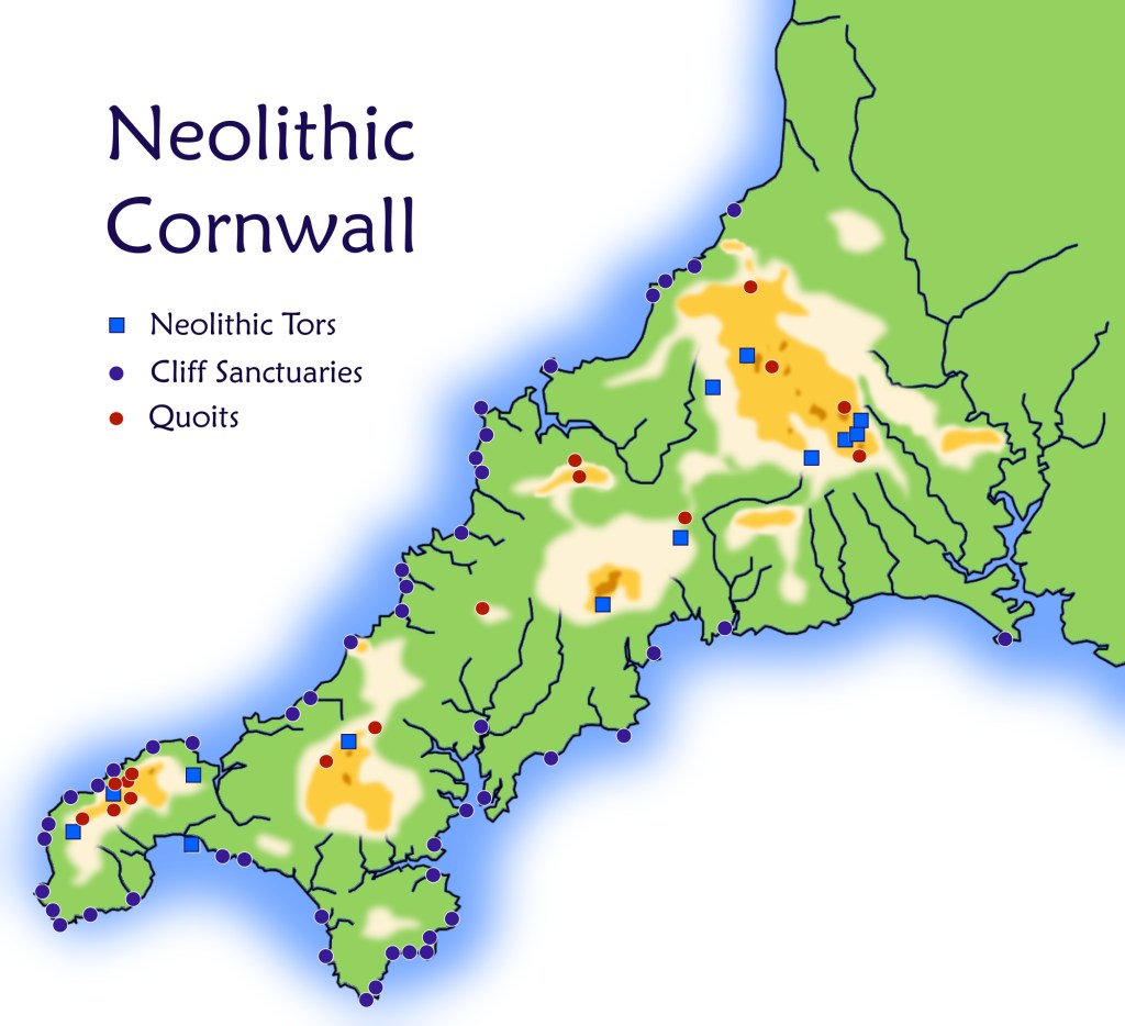
This is about the ancient sites of West Penwith in Cornwall, where I live. It runs through the prehistory of this area from the Mesolithic, through the Neolithic and the Bronze Age to the Iron Age, featuring particularly the megalithic periods of the Neolithic and Bronze Age – the time of the quoits, menhirs and stone circles.
It will be of interest to locals in Cornwall, or people from elsewhere who visit our ancient sites, or people with a general interest in prehistory and megalithic times.
It’s in four episodes – and for binge-listeners there’s a three-hour omnibus edition. If you prefer reading, there’s a PDF version of this short book that can be read on-screen or printed out.
Originally it was part of my book Shining Land, about the ancient sites of West Penwith, but I took it out because it made Shining Land too long. It works well on its own.
Britain has had two periods of national greatness. One was the 250-year empire-building period in relatively recent times, and the other was the Bronze Age and a megalithic civilisation that lasted a thousand years. This is its story, as it happened in West Cornwall, one of the hubs of megalithic activity in NW Europe 4,000 years ago.
If this interests you, I hope you enjoy the book! It’s free to stream or download.
It’s funny how sometimes we fall into things unwittingly, then to find that they take up years of our lives. This is what happened with my research into the ancient sites of the area where I live, in West Penwith, Cornwall. It all started one day when I was sitting chatting with Cheryl Straffon, an archaeologist and goddess-oriented pagan who for decades has been a key person here, bringing together a full spectrum of prehistorians, from archaeologists to pagans, and editing Meyn Mamvro, a magazine about Cornish archaeology and earth mysteries.
We were talking about John Michell who, in the 1960s-70s, brought the idea of leylines, sacred landscapes and earth mysteries to wider attention in a seminal 1969 book The View over Atlantis. John came to Penwith, doing fieldwork here to demonstrate his point, producing a catalogue of ninetyish ancient site alignments in Penwith, about which he wrote in his 1974 book The Old Stones of Land’s End.
I asked Cheryl whether anyone had made a map of the alignments John had found. No, she said. Hmmm. In former times, I had made a map of the alignments around Glastonbury… “Would it help if I made an alignments map of Penwith?“. “Oooh, yes, it would.“
I thought at first that it might be easier than it turned out to be. It landed up being seven years of work, starting in 2014, and it still gets tweaks and updates now. I’d had one of those falling-into-things moments, just then.
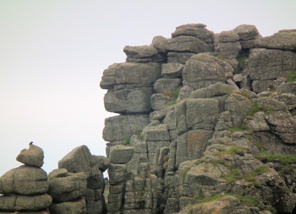
Carn Galva, a classic Neolithic Tor and the axis mundi or world centre of Neolithic Penwith – as seen from Caer Brân
Things had changed since I did the Glastonbury map, hand-drawn in 1982 and revised around 2003. Aerial satellite mapping had arrived on internet. For alignment-oriented geomancers like me this greatly changed the equation, opening up many new possibilities and making alignments maps easily accessible online to the public.
At the beginning it came clear that a genuinely useful map would need to show all of the known ancient sites in Penwith. But there are more than 800 of them, big and small, surviving or destroyed, so this was no small job. They were listed in a variety of online databases which, to complicate things, sometimes gave differing or inaccurate information, so every single site had to be examined closely.[1] I spent months trawling through these sources and building up a base map on which later to mark alignments. Later on I continued the mapwork to cover Scilly and the whole of Cornwall.
Some sites were difficult to confirm, being disappeared, disputed or subject to discussion. Some were visible in the field and others, now destroyed, were beyond trace, though many are mentioned in antiquarians’ records from former times – especially those of one called Dr William Borlase, who tramped around Penwith in the mid-1700s.[2]
Eventually I completed a map of Penwith’s sites. Then it was a matter of working through John Michell’s list of ninetyish alignments, plus others found since his time and listed in Meyn Mamvro.
One can argue till the end of time about the validity of megalithic alignments and sceptics love to do so, claiming an assumed authority of scientific rationality when, to me, all that these complaints demonstrate is that sceptics have not properly researched the matter. There is a simple, evidential, inescapable fact: ancient sites are commonly located in exact alignment with each other. This can be seen and checked by anyone on maps and in the field.
That’s the evidence, whether or not we have an explanation. It happens too much, too exactly and with too many supporting details to be a case of chance or randomness. There are discernable patterns to the specific nature of differing alignments – some are made up solely of cairns or menhirs (standing stones), or they link sites of similar antiquity, or they make some sort of sense in a wide variety of ways. Some alignments are even parallel.
If you look at the online map of Penwith’s alignments [3] it looks like a meaningless jumble with only a modicum of order to it. There’s a ridiculously large number of alignments and it’s difficult figuring out how and why the megalith builders went to the trouble of setting things up like this.
But when you look closer at individual alignments and the sites they connect, they begin making more sense. It’s worth remembering that the ancients walked everywhere, so a lot more happened for them in the space of a mile than it does for us, speeding along in our cars and looking at overview maps.
What is most interesting is that alignments stretch not just between man-made sites, but they also involve natural sites such as hilltops, carns (outcrops) and cliff promontories. The whole system is based on these prominent points – I call them ‘base sites’. The pattern of ancient sites is draped over the three-dimensional canvas of the Penwith landscape and arranged around it. There are also astronomically-oriented alignments and other factors such as energy-vortices, underground and overground energy lines, site intervisibility and even geometry that are involved in the positioning of ancient sites. [For more on this, here’s a talk by me.]
Entering Michell’s ninety alignments on the map, I found that only two were inaccurate and implausible, and I removed them. He had done good, accurate work. While making the map and checking the alignments, I started finding new ones and, before long, the list of alignments grew bigger. Some were found logically, by examining a chosen site to check for alignments, and some were found intuitively, happening on them ‘by chance’. After visiting sites around the fields and moors of Penwith, I would come home to examine their location and possible alignments, sometimes adding a few that way.
Late one evening I had a Eureka moment. I was thinking about Cape Cornwall, a conical-shaped headland in a marine context, and St Michael’s Mount, a conical-shaped island in a marine context (though originally it stuck out of the forest on dry land). They are rather similar. I wondered whether there was a connection. I looked on the map and, lo behold, a line between them intersected a collection of four Bronze Age barrows on top of the hill on the farm where I live!
Gosh. I had sat many times on those barrows.[4] They are not well-known because, being on what’s now a boggy heather-moorland hill, they look unimpressive, but their 360-degree panoramic location is spectacular. In the Bronze Age they would have been far more attractive, situated on sweet hilltop meadows – the climate was more agreeable 4,000 years ago than it is now.
Then I started looking for further alignments emanating from St Michael’s Mount and Cape Cornwall. Within an hour I had found quite a few. This doesn’t happen very often – I’ve never had such a big discovery of new alignments before or since. These proved to be a new kind of alignment that John Michell and others had not seen.
John was looking at constructed Bronze Age sites such as stone circles, menhirs, cairns and barrows, which were built from around 2400 BCE onwards. The new alignments I had found involved Neolithic sites from a millennium earlier, and natural sites such as granite tors and cliff headlands. These alignments acted differently to Michell’s Bronze Age ones, covering longer distances and with fewer points on them. I called them ‘backbone alignments’ – alluding to the main system of fibre-optic cables that connects the internet globally. Connecting Neolithic and natural sites, these alignments were clearly far older than John’s Bronze Age ones.
The very first constructed sites in Penwith, Neolithic tor enclosures, were built around 3700 BCE – over a millennium before the stone circles. There were four – Carn Galva, Carn Kenidjack, Trencrom Hill and St Michael’s Mount – and one outside Penwith that features in its landscape, Carn Brea near Redruth.
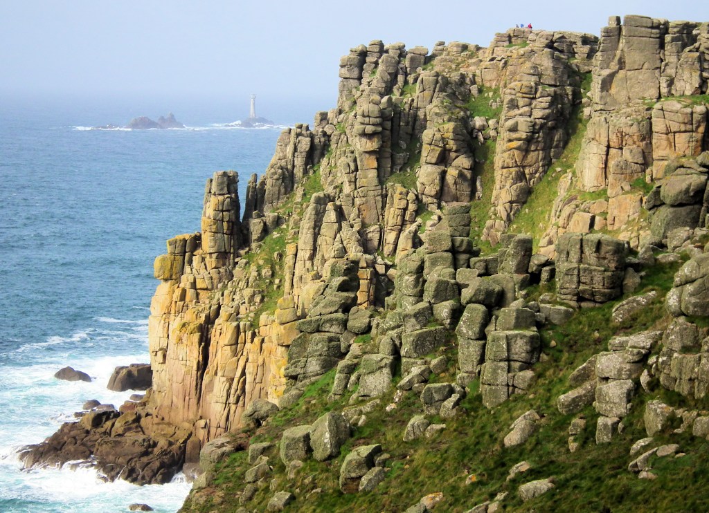
Many of the newly-discovered backbone alignments also stretched to what I call cliff sanctuaries. Archaeologists call them cliff castles – a term that persuades many people to believe they were used for defensive purposes, which I would argue they were not. They are customarily dated to the Iron Age around 300 BCE, long after the megalithic period, because Iron Age remains are found on them. But the new alignments, associating them with Neolithic sites, suggest they were much older in the first use. Neolithic artifacts have been found at some cliff sanctuaries, but these have not caused them to be properly re-dated to this early time.
Then came the clincher. I found that Lanyon Quoit, one of the key Neolithic sites of Penwith, built around 3600 BCE, was located exactly at the intersection of three of these alignments. In other words, Lanyon Quoit could not have been placed where it is without these three alignments being known at the time – it was positioned to align with two cliff sanctuaries and three Neolithic tors. This definitely re-dates the cliff sanctuaries to the Neolithic, also making them far more important than they previously were understood to be.
Penwith’s four surviving stone circles are all located on backbone alignments. The Merry Maidens, for example, are located exactly on an alignment stretching between Carn Brea and St Michael’s Mount, both Neolithic tors, and Treryn Dinas, a cliff sanctuary. These three natural sites happen, strangely, to be aligned with each other (there are a number of such cases in Penwith). So the stone circle was located there to reinforce the alignment and to draw on the antiquity and earlier primacy of the three Neolithic sites, which came from what in the Bronze Age was a distant former time, some 1,500ish years before.
Eventually, the alignments map of Penwith became really busy with alignments – around 250 of them. They were all genuine alignments, accurate to within 10ft or 3 metres, checked and verified by three people – so this was not a product of sloppy mapping, wishful thinking or ley-hunting zeal.
Alignments are not energy-lines of the kind that is picked up by earth energy dowsers. They are different, even though overground energy lines, like alignments, are also straight. Some overgrounds coincide with alignments, but we yet need to find out the extent to which this is the case.
Trencrom Hill (foreground) and Carn Brea (background) – two Neolithic tors
I’m of the opinion that alignments are not actually lines that are detectable in the landscape. Some dowsers might disagree, but I think they might be picking up on overground energy-lines, or perhaps the thought that links the two sites involved. Instead, it seems that, when a new site was being built, it was simply aligned with other sites in order, presumably, to associate it with them. If you line up five or six objects on a table with gaps between them, aligning them nevertheless gives their distribution some order and coherence. Rendering order out of seeming chaos was important to the ancients. But aligned sites don’t seem to have a connecting current like overground energy-lines do.
It seems to me that aligned sites are instead programmed with the same algorithm, so that they pulsate and resonate with each other, as if tuned to each other. But there isn’t a ‘wire’ connecting them – it’s an internal, implicit connection. It works a bit like what physicists call ‘quantum entanglement’, and as an informational rather than an energetic relationship. An energetic relationship is created by energy-lines that dowsers identify, but alignments don’t do this. So we’re talking here about two different circuitries that each focused on the same ancient sites. And it’s the sites, not the lines, that matter most.
Many ancient sites are thus placed exactly where they are to align them with other sites, though there is no ‘pipe’ connection between them. Instead, they seem to be remotely associated, programmed with the same intent, frequency or behavioural patterns, so that they do similar things at similar times and in similar ways. But they aren’t necessarily directly connected, unless there is also an energy-line between them.
Thus, the Boscregan West cairn, a prominent clifftop cairn on Penwith’s west coast, is aligned with the Neolithic longbarrow on Chapel Carn Brea, and with the now-destroyed Tregurnow stone circle, which was part of the Merry Maidens complex. So these three sites, associated with each other, somehow co-resonated. Or, put another way, two Bronze Age sites, Boscregan cairn and Tregurnow stone circle, were plugged into a Neolithic site on Chapel Carn Brea.
The cliff sanctuaries, embracing the Radiant Land
Interesting, huh? The megalith-builders had quite sophisticated ideas. They weren’t building ancient sites just to decorate the landscape or because it was a nice thing to do. It was a lot of work. They can only have done it because they perceived a definite benefit.
Here’s a much bigger idea. The density of sites and alignments in Penwith, and the way they seem to be integrated into complex relationships with each other, suggest that they operate as one big system. The fundamental substructure is marked out by backbone alignments (yellow on the map), and while the profusion of local alignments (red on the map) seems chaotic to our eyes, it has a certain order of its own. They all seem to make up one big system.
This leads us to the idea that Penwith is an integrated and perhaps super-charged landscape with hundreds of constituent components to it, big and little. That’s the way we should think about it, and not as a disparate scatter of separate sites. After all, Penwith’s ancient name is Belerion – the radiant land – and a place doesn’t pick up a name like that without good reason.
While Penwith’s stone circles and other sites are each modest in size when compared with Stonehenge, Avebury or Callanish, together they make up an enormous system contained by a necklace of cliff sanctuaries and studded with many subsystems. They constitute what can be regarded as a single, big ancient site that is draped over the peninsula’s natural topography and energy-centres.
Each stone circle has a complex or constellation of lesser sites around it – mainly menhirs and barrows. These supporting sites and the surrounding landscape vista exist as an integral part of the stone circle to amplify its purpose – a stone circle doesn’t exist in isolation. In the case of Boscawen-ûn and the Merry Maidens the surrounding agricultural landscape of hedges and fields obscures their wider complexes, but at Tregeseal and the Nine Maidens, located in wilder landscapes, they are more visible.
Tregeseal, for example, sits in a perceptual bowl of hills with a westward vista featuring the Isles of Scilly – almost as if the sweep of hills collects energy from the cosmos to funnel it toward the Scillies. Each stone circle is associated with a hill or tor that is visible from it and a key part of its landscape setting. These complexes are whole systems. In turn, they are aligned with other sites further away, knitting the whole of Penwith into a wholeness.
The stone circles are located on backbone alignments plugged into Neolithic sites – tors and cliff sanctuaries which, in the heavy-forested Neolithic, were the only places where people could get out of the wildwoods. This changed in the Bronze Age, with far more cleared land, which enabled the building of stone circles, menhirs and cairns, but the stone circles, as the ‘cathedrals’ of the system, drew their primacy, authority or blessing from earlier Neolithic sites.
They are key nodes planted in a landscape energy-system with a natural, topographic, geological and subtle-energy foundation. The system fashioned itself around the lay of the land. Here we come to the idea of landscape temples, or whole landscapes that have been developed and consecrated by amping up the natural energies inherent in the land. This was done not only through ‘megalithic geoengineering’ at sacred sites but also through repeated, longterm consciousness-work by successive generations of people. This was an advanced deep-shamanic culture. They imprinted their sacred sites and landscape with repeated and reinforced psychic traces of the shamanic and spiritual practices they conducted over many centuries. They loved the land that gave them a life to live.
An approximate timeline for megalithic Penwith
There is a key aspect of ancient sites that archaeologists miss, and without it ancient sites cannot truly be understood: it concerns earth energy and its psychoactive effects, especially when they are focused and enhanced at man-made ancient sites. These effects cannot easily be detected scientifically, but any person with a modicum of awareness can feel them when visiting sites. We become changed in mood and spirit, sometimes feeling inspired, healed or as if our problems have evaporated. Some people are changed for life – for me, five decades of preoccupation with ancient sites began in 1970 in the Ring of Brogar, a stone circle in the Orkney Isles off Scotland.
These psychoactive effects are a key factor that should be considered ‘legitimate evidence’, regardless of whether or not it can be measured or slotted into existing scientific frameworks. You do not need a doctorate to feel these effects: simply note your feelings and state of being before you enter and after you leave a stone circle. There will be a real change of feeling. Fascinatingly, it can also be quite different in quality and effect each time you visit.
This, I suggest, is a key reason why the ancients went to so much trouble heaving stones around, digging and piling up earth, and doing regular, intentional, collective consciousness work at ancient sites. They spent centuries building up a sophisticated landscape-wide energy-system, and they must have perceived this massive infrastructure investment to be beneficial and worth the effort.
If they had been deluding themselves, it is unlikely that the Bronze Age megalithic period would have lasted 1,200 years. Delusions don’t tend to last that long. There was something very sensible and realistic about the megalithic geoengineering they developed. With our planetary problems of today, we might do well to learn more about what they were up to.
Here’s a final thought. Since right now the world is rather obsessed with warfare, we might also ask ourselves how and why West Penwith is one of the few parts of Britain that has never been invaded – not by Romans, Saxons, Vikings or Normans. In later times Penwith was quietly regarded as lying ‘beyond the reach of the king’s men’. We’ve had some medieval Corsair raids and in the last century or so a seasonal tourist invasion, but Penwith has never actually been invaded. But that, of course, is pure luck and chance, isn’t it?
NOTES:
The main sources were: Heritage Gateway, Historic England, Cornwall Council, Megalithic Portal, Modern Antiquarian, Meyn Mamvro, The Holy Wells of Cornwall map, The Atlas of Hillforts and snippets from other books and sources.
This is for people living in or near Cornwall. Audio recordings of the talk, with accompanying material, will appear online a week or so after the talk, for those who cannot attend.
In my talk in June about the ancient sites of West Penwith (worth a listen) I proposed that the whole of Penwith is one big ancient site – an enormous cliff sanctuary. It’s not just a scattering of stone circles, quoits, carns, menhirs and cairns. Why did ancient Penwithians bother to build so much of this ‘holy machinery’? What was their thinking and what did they seek to achieve?
I’ve been studying ancient sites since around 1970 in Britain, Scandinavia, Greece and Palestine. Since moving to Penwith in 2009, I’ve been working on mapping Penwith’s sites, researching their (John Michell-style) alignments, and divining some valuable psychic-intuitive clues concerning their possible meaning and function. These observations are outlined on the Ancient Penwith website and in my book Shining Land.
In the first half of this evening’s talk, I go further into the sacred energy-technology of Neolithic and Bronze Age Penwithians, and the patterns that suggest that they function as one big megalithic system. We’ll look into how it all took shape from the beginning, the functions of different kinds of ancient sites, and how it all fits together into one big geomantic system.
In the second half I propose what I feel needs to happen next, in terms of researching and working with Penwith’s ancient sites. We need to find out more about how they actually work, geomantically and energetically, and what we can do now to enhance and re-enliven their energy-fields and world-healing qualities – not just an hour-long ceremony now and then, but sustained energy-work, learning more about the specifics of how to do it.
Penwith is an ideal area for this kind of work because it is concise and contained, with plenty of ancient sites and people interested in them. Also, this is Cornwall, not England, and Oxbridge-style archaeological thinking is not the only way to understand megalithic civilisation – here in Penwith, out of sight and out of mind, we have an opportunity to frame things in a rather different way.
There is the possibility of starting a research project involving 10-20 people, in which (say) about forty local sites are surveyed, mapped and chronicled by dowsers and sensitives over (say) a three year period, for their subtle energy characteristics and place-memory. (See below for a shortlist of sites.)
Steadily and systematically, we can visit the sites and truly listen to what they want to say – not imposing our own ideas and predilections but letting the sites and the landscape speak, using methods such as pendulums, meditation, inner journeying and talking stick as research methodologies. Then a report (or a series of them) or a website can report on the findings uncovered by the project.
So I’m wondering out loud whether we need now to take things further, stepping beyond a ‘Wow’ stage to try realistically to penetrate the minds of the Neolithic and Bronze Age megalith builders, to uncover more about ancient sites’ energy-mechanics, their intention and usage, and what we can do about them now. That’s what this evening is all about and, if you can, you’re welcome to come and join in.
This is a recording of a talk I gave on Wednesday 19th in Penzance, here in Cornwall. It would interest anyone who knows and loves West Penwith, and also folks interested in geomancy and alternative prehistory.
It’s about energy-fields, ancient site alignments and the geomancy of ancient sites. I make a radical proposition that the hundreds of sites in Penwith all constituted components of one enormous ancient site covering the whole peninsula.
A collection of interesting maps is provided with the recording of the talk, which is 1hr 48mins long.
To follow in autumn in Penzance, there will be four monthly AHA classes, covering activism (changing the world), prehistory (more about Magic Penwith), power points in time (astrology and the way the tides of time move) and extraterrestrials (about life off and on Earth).
I’m speaking at the Glastonbury Symposium on Sunday July 28th, and I return to Glastonbury on my birthday on 5th September. The subject is ‘Sludging through the Void with Muddy Boots – and why ETs have spindly legs‘.
If you want a really special experience, you might consider coming to the Oak Dragon Camp, Friday 26th July to Sunday 4th August in Somerset. I’ll be there. www.oakdragon.org
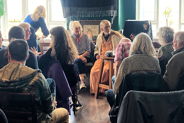
On Sunday, Ba Miller and I shared the floor in Penzance, speaking to a lovely crowd, on the occasion of the late Hamish Miller’s 97th birthday.
Ba herself is 91 – though, with me at 73, a mere stripling, we’re both beat-up and still going strong!
Ba told some anecdotes of what happened when they were following the Apollo and Athena lines from Ireland to Israel, and some really valuable dowsing tips (since it was also World Dowsing Day).
I talked about the energy-landscape of West Penwith, about building megalithic structures for consciousness-engineering and how Penwith is one big ancient site with hundreds of components.
A big thank you to Rachel, Lucy and Lyndz for initiating and organising it, and for their rousing spirit.
To hear our talk (1h 15m), go to my Audio Archive and look for ‘2024 PodTalks’:
Also: my latest book, Blessings that Bones Bring – a spirited Myeloma patient tells his cancer story, is coming out soon in digital PDF format, and before long as an audio book. Whether it gets published in print remains to be seen.I’ll let you know when it’s available.


You must be logged in to post a comment.