This is for people living in or near Cornwall. Audio recordings of the talk, with accompanying material, will appear online a week or so after the talk, for those who cannot attend.
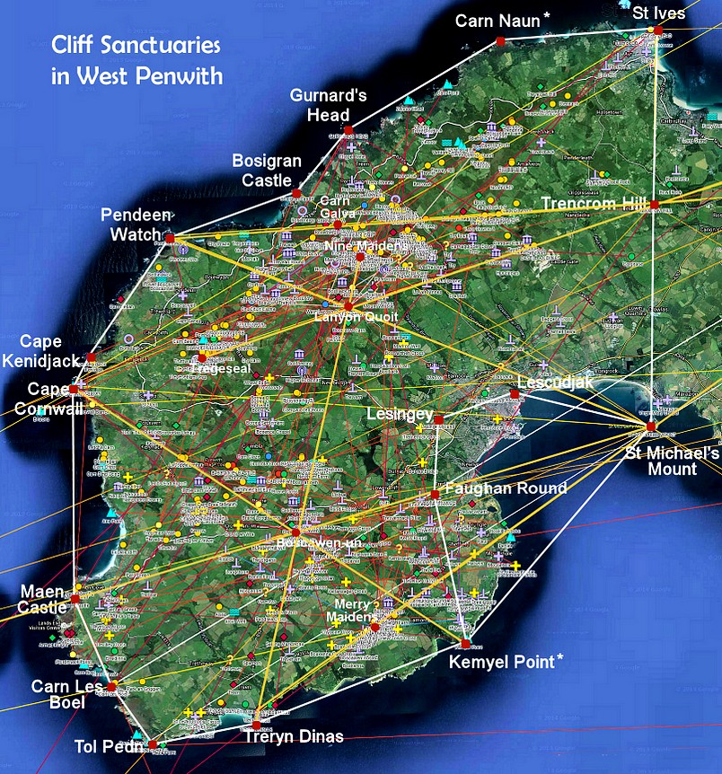
In my talk in June about the ancient sites of West Penwith (worth a listen) I proposed that the whole of Penwith is one big ancient site – an enormous cliff sanctuary. It’s not just a scattering of stone circles, quoits, carns, menhirs and cairns. Why did ancient Penwithians bother to build so much of this ‘holy machinery’? What was their thinking and what did they seek to achieve?
I’ve been studying ancient sites since around 1970 in Britain, Scandinavia, Greece and Palestine. Since moving to Penwith in 2009, I’ve been working on mapping Penwith’s sites, researching their (John Michell-style) alignments, and divining some valuable psychic-intuitive clues concerning their possible meaning and function. These observations are outlined on the Ancient Penwith website and in my book Shining Land.
In the first half of this evening’s talk, I go further into the sacred energy-technology of Neolithic and Bronze Age Penwithians, and the patterns that suggest that they function as one big megalithic system. We’ll look into how it all took shape from the beginning, the functions of different kinds of ancient sites, and how it all fits together into one big geomantic system.
In the second half I propose what I feel needs to happen next, in terms of researching and working with Penwith’s ancient sites. We need to find out more about how they actually work, geomantically and energetically, and what we can do now to enhance and re-enliven their energy-fields and world-healing qualities – not just an hour-long ceremony now and then, but sustained energy-work, learning more about the specifics of how to do it.
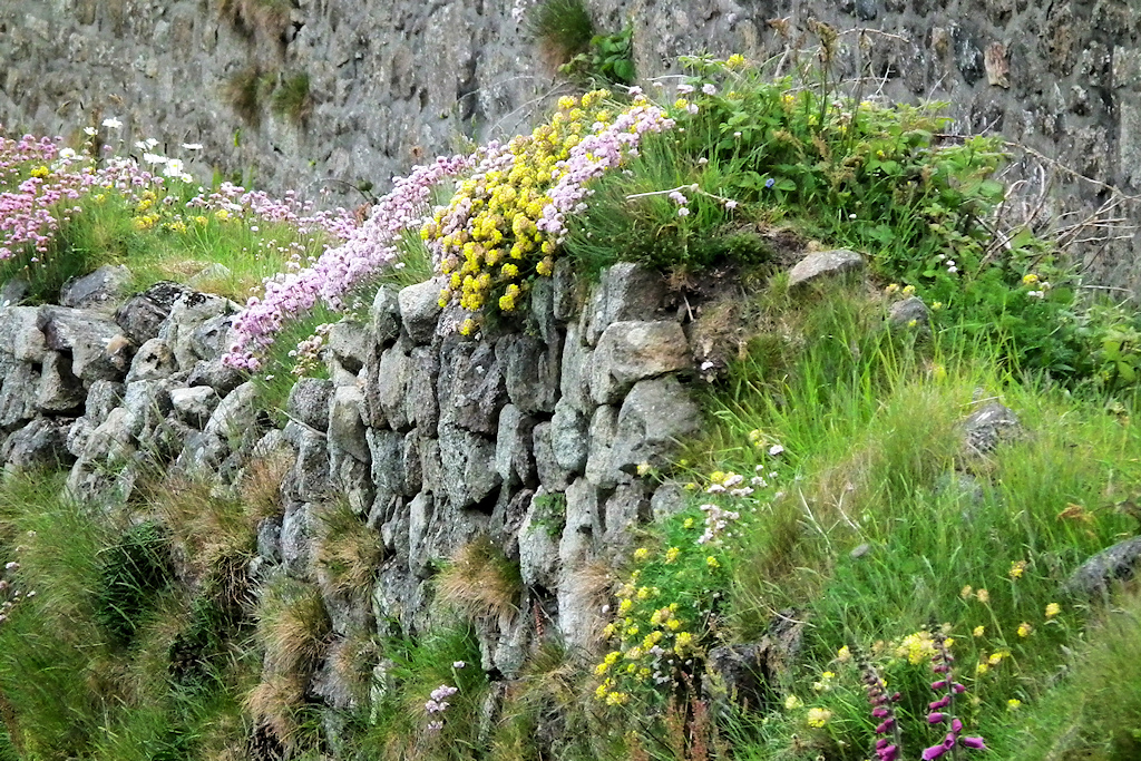
Penwith is an ideal area for this kind of work because it is concise and contained, with plenty of ancient sites and people interested in them. Also, this is Cornwall, not England, and Oxbridge-style archaeological thinking is not the only way to understand megalithic civilisation – here in Penwith, out of sight and out of mind, we have an opportunity to frame things in a rather different way.
There is the possibility of starting a research project involving 10-20 people, in which (say) about forty local sites are surveyed, mapped and chronicled by dowsers and sensitives over (say) a three year period, for their subtle energy characteristics and place-memory. (See below for a shortlist of sites.)
Steadily and systematically, we can visit the sites and truly listen to what they want to say – not imposing our own ideas and predilections but letting the sites and the landscape speak, using methods such as pendulums, meditation, inner journeying and talking stick as research methodologies. Then a report (or a series of them) or a website can report on the findings uncovered by the project.
So I’m wondering out loud whether we need now to take things further, stepping beyond a ‘Wow’ stage to try realistically to penetrate the minds of the Neolithic and Bronze Age megalith builders, to uncover more about ancient sites’ energy-mechanics, their intention and usage, and what we can do about them now. That’s what this evening is all about and, if you can, you’re welcome to come and join in.
This is a recording of a talk I gave on Wednesday 19th in Penzance, here in Cornwall. It would interest anyone who knows and loves West Penwith, and also folks interested in geomancy and alternative prehistory.
It’s about energy-fields, ancient site alignments and the geomancy of ancient sites. I make a radical proposition that the hundreds of sites in Penwith all constituted components of one enormous ancient site covering the whole peninsula.
A collection of interesting maps is provided with the recording of the talk, which is 1hr 48mins long.
To follow in autumn in Penzance, there will be four monthly AHA classes, covering activism (changing the world), prehistory (more about Magic Penwith), power points in time (astrology and the way the tides of time move) and extraterrestrials (about life off and on Earth).
I’m speaking at the Glastonbury Symposium on Sunday July 28th, and I return to Glastonbury on my birthday on 5th September. The subject is ‘Sludging through the Void with Muddy Boots – and why ETs have spindly legs‘.
If you want a really special experience, you might consider coming to the Oak Dragon Camp, Friday 26th July to Sunday 4th August in Somerset. I’ll be there. www.oakdragon.org
On Sunday, Ba Miller and I shared the floor in Penzance, speaking to a lovely crowd, on the occasion of the late Hamish Miller’s 97th birthday.
Ba herself is 91 – though, with me at 73, a mere stripling, we’re both beat-up and still going strong!
Ba told some anecdotes of what happened when they were following the Apollo and Athena lines from Ireland to Israel, and some really valuable dowsing tips (since it was also World Dowsing Day).
I talked about the energy-landscape of West Penwith, about building megalithic structures for consciousness-engineering and how Penwith is one big ancient site with hundreds of components.
A big thank you to Rachel, Lucy and Lyndz for initiating and organising it, and for their rousing spirit.
To hear our talk (1h 15m), go to my Audio Archive and look for ‘2024 PodTalks’:
Also: my latest book, Blessings that Bones Bring – a spirited Myeloma patient tells his cancer story, is coming out soon in digital PDF format, and before long as an audio book. Whether it gets published in print remains to be seen.I’ll let you know when it’s available.
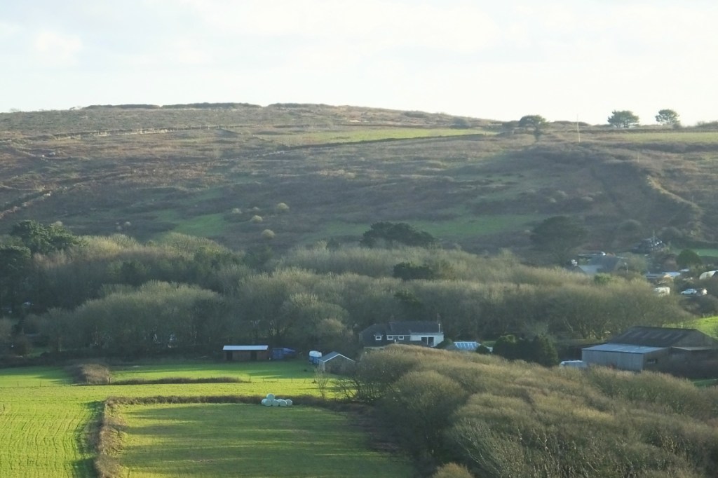
This 30 minute podcast is recorded while sitting in the remains of an Iron Age Courtyard House, up the hill on the farm where I live.
It doesn’t look very exciting nowadays, though it’s a nice place – but then, if you were 2,000 years old, you might be a bit worse for wear too!
This podcast is all about what life was like in the Iron Age in Cornwall, two millennia ago, and the way people saw things then.
Looking into the yard of the courtyard house. Behind are Sancreed Beacon (left) and Caer Brân (centre right), and far behind them is the hill on which the Merry Maidens stone circle sits.
This was the Celtic period – though the Celts shared a culture, and they were not one people. In West Cornwall many were descendants of the indigenals of the Bronze Age.
It’s about life and reality systems in our time, and in the Iron Age, and also in the Bronze Age and the Neolithic – how people saw life and the world in each of these periods, and how their technologies reflected that.
With some insights into what we can learn from them now. This is important. As elder dowser Sig Lonegren often used to say, quoting his Seneca teacher Twylah Nitsch, ‘We seek not to emulate the ancient ones – we seek what they sought‘.
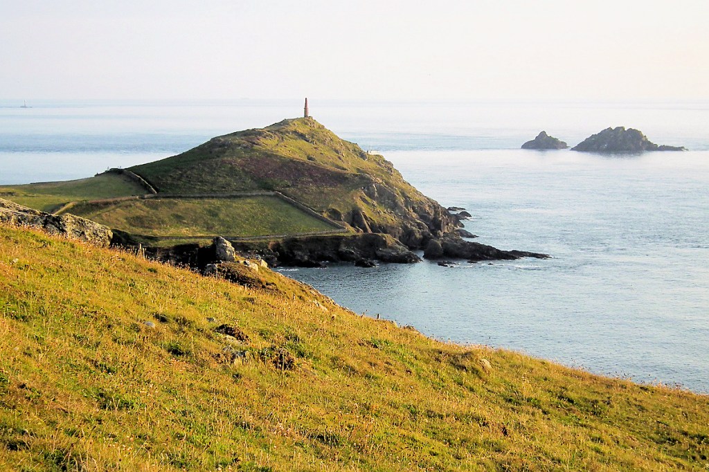
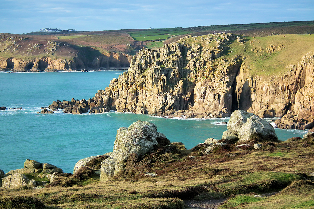
Geomantic secrets. This is a telephoto shot of Carn Kenidjack, a Neolithic tor, seen from atop a barrow five miles away at Carn Les Boel, a cliff sanctuary. Here’s the rub: step off that barrow and you can no longer see Carn Kenidjack. That sightline is important.
Over the last month I’ve been doing a complete revision and rewrite of the Ancient Penwith website and, with relief, this morning, on the Piscean new moon, I uploaded it all.
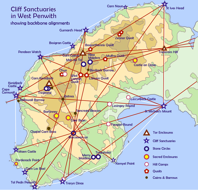
This is the key map that illustrates my main point in this work: that Penwith was an integrated ancient site and cliff sanctuary covering the whole landscape. That integrated system was pegged out between the cliff sanctuaries and Neolithic tors of the peninsula.
I built the site in 2015-19 in connection with my researches into Penwith’s ancient sites and geomancy, leading out of the ancient sites and alignments maps I was also making at the time. Initially the maps covered West Penwith though, by 2019, I had extended it across the whole of Cornwall. The maps, together with fieldwork, were the basis of the research.
It’s a resource site focused on the alternative archaeology and geomancy of West Penwith, as I understand it. In a way it’s a bit like the course on that subject that I never taught. It’s now around 100 pages in size and quite comprehensive.
There will be tweaks and amendments in coming weeks. If you find glitches, errors or dead links, please tell me their page and location! Thanks.
I’m not sure how much longer I have to live (being a cancer patient) and God usually doesn’t tell you when your bucket-kicking initiation will come – so this rendering of the site might be a parting shot. Whatever is the case, do enjoy trawling through it. It’s for you.
Whether or not you agree with this kind of stuff, there are gems there for the finding, and archaeologists will definitely miss something if they omit to give it a trawl and a good think – and a feel too. It’s all a matter of what we consider to be viable and useful evidence, and what conclusions we draw from it.
Near-parallel alignments across West Cornwall
This work is probably incorrect in some details, but the overall points made suggest that this peninsular landscape was built over many centuries into a single large, integrated ancient site and cliff sanctuary. One symptomatic outcome of this is that it has never been forcibly invaded. Well, except perhaps by tourists during summertime.
Have fun! With love, Palden
Archaeoastronomy. The summer solstice sun setting between Trink Hill, left, and Rosewall Hill, right, as seen from the top of Trencrom Hill, a Neolithic tor. This isn’t man-made – this is natural. Think about it…
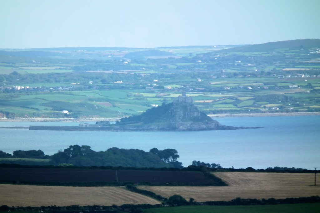
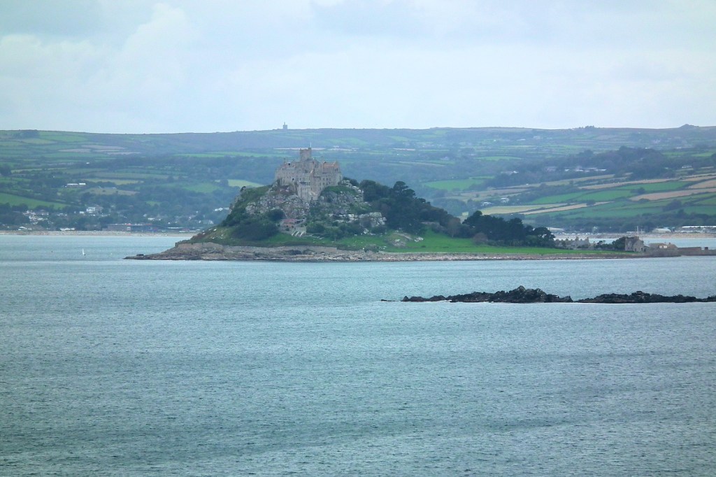
St Michael’s Mount from Botrea Barrows (telephoto shot)
One of the strange gifts that cancer gives is the prospect of dying soon. It’s is a motivator. You can’t leave things till later or leave them incomplete. So I’ve been moved to bring things to completion as much as I can – with success in some areas and less in others. One area I’m focusing on wrapping up now is my study of the Megalithic period of the Neolithic and Bronze Ages.
For the last ten years I’ve been researching ancient sites in West Penwith, where I live, drawing on fifty years of study and experiences in Britain, Scandinavia, Greece, Jordan and Palestine. Having done an alignments map of Glastonbury twenty years ago,[1] in 2014 I started making a map of the ancient sites and alignments in Penwith.[2]
West Penwith, the shining land of Belerion, has more ancient sites per square mile than anywhere in Europe. It’s the far promontory at the very end of the long southwestern peninsula of Britain. Surrounded by cliffs on three sides, it has a distinct energy-boundary on the landward, eastern side, made up of three hills lying in a straight line – St Michael’s Mount, Trencrom Hill and St Ives’ Head. On the A30 to Penzance it crosses the road by the shop in the village of Crowlas.
Alignments in Penwith have been studied over the decades by John Michell and a number of other researchers. John wrote the 1974 book ‘The Old Stones of Land’s End’, identifying around ninety alignments involving mainly Bronze Age and early Christian sites. Checking these alignments with online satellite mapping, not available in John’s day, I found that only two of the ninety were inaccurate and questionable.
Cape Cornwall or Kilgooth Ust, with the Brisons Rocks behind
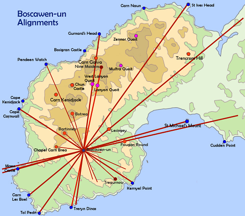
Then late one night came a Eureka moment, after an evening working on the Penwith map. I was tired yet unready to go to bed. I sat there musing about St Michael’s Mount, a roughly conical hill in a marine setting, and then about Cape Cornwall, a prominent headland near me, with a similar character. Both were prominent ancient sites on either side of the peninsula.
Spontaneously I got out a ruler, placing it between the two sites to see if an alignment was there. Lo behold, indeed there was. It passed through a set a four barrows up on the top of the hill on our farm, not far from my house. Gosh, that was a surprise.
One of the Botrea Barrows
I spend a lot of time up at Botrea Barrows and, though they don’t look impressive, they have a remarkable panorama and they certainly have that distinct feeling you get at an ancient site that is still energy-alive. It’s a feeling of being changed in mood and perspective, energy-bathed, both calmed and energised.[3]
A lightbulb lit up. I started checking to see whether there were further alignments like this. The Mount and Cape Cornwall are both cliff sanctuaries. They form a necklace of magic headlands around Penwith, and also much of Cornwall and parts of Devon (there’s a big one in Somerset called Brean Down). So I started checking other cliff sanctuaries and suddenly a lot of new alignments appeared. Normally called cliff castles, they aren’t defensive, and they’re not just beautiful places but also they have a special feeling of being consecrated, so I call them cliff sanctuaries.
I found about eight alignments in twenty minutes – a record never again repeated, since usually they don’t come easily. Not only this, but many of the alignments connected with Neolithic tors, the very first dedicated ancient sites in Penwith, Cornwall and Dartmoor. There are five in this area: Carn Brea, the Mount, Trencrom Hill, Carn Kenidjack and Carn Galva.
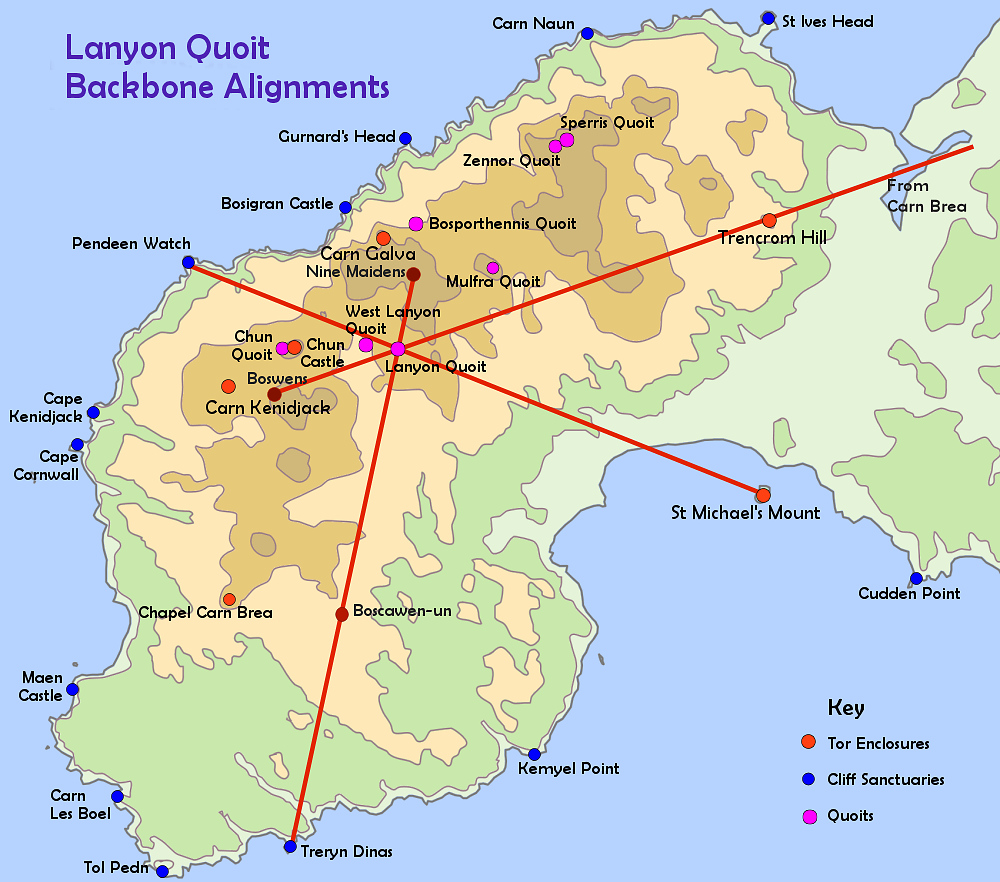
Something interesting emerged. Three of these newfound alignments crossed exactly at Lanyon Quoit. One came from Carn Brea near Redruth (a Neolithic tor), through Trencrom Hill (a Neolithic tor), Mulfra Quoit and Lanyon Quoit (Neolithic quoits or cromlechs). It continues to the Tregeseal stone circle complex and eventually to the Brisons Rocks off Cape Cornwall. This implies that, when it was built in the Bronze Age, Tregeseal was deliberately placed on this alignment, or that the site was known in the Neolithic even if it took a millennium to build a stone circle on it.
Another alignment went from St Michael’s Mount (a Neolithic tor) through Lanyon Quoit to Pendeen Watch (a cliff sanctuary). A third alignment went from Treryn Dinas (a cliff sanctuary) through Boscawen-ûn stone circle and Lanyon Quoit to Bosiliack Barrow and a proxy menhir at the Nine Maidens stone circle. Thus, the location of stone circles is significantly determined by these alignments (though multiple interlocking factors are usually involved).
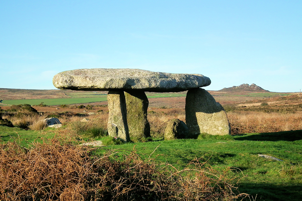
Lanyon Quoit, with Carn Galva behind. Lanyon Quoit is not in its original shape – it fell down in Victorian times and was incorrectly re-erected.
That sounds straightforward, but the implications are quite big.
Lanyon Quoit was built around 3700-3500 BCE, as were the enclosures built to encircle the Neolithic tors. Since the quoit’s precise position is fixed by these three alignments, each aligning with tors or cliff sanctuaries, it means that cliff sanctuaries date back in their first us to at least that time. In one fell swoop, the number of Neolithic sites in Penwith doubled.
Cliff sanctuaries are not usually regarded as major ancient sites.[4] This discovery changes that. Archaeologists ascribe them to the Iron Age around 2,500-2,000 years ago. But we now have geomantic evidence that they were far older in first use and far more important. They were consecrated – you can feel this when you visit them, since they don’t have the same feeling as other headlands. To test this, visit Zennor Head, an ordinary headland, and then neighbouring Bosigran Castle and Gurnard’s Head, both cliff sanctuaries. They’re special. The discovery of Neolithic archaeological remains at some of them hasn’t caused archaeologists to drop their attachment to Iron Age fortresses though.
These new alignments I call ‘backbone alignments’. They are different from the alignments John Michell and most ley-hunters studied, involving Bronze Age sites such as stone circles, cairns and menhirs. In Penwith, what’s special about the backbones is that they represent a more coherent order than the Bronze Age alignments. I’m surprised no one has discovered them before.
More implications… The backbones reveal a coherent structure to the 600 ancient sites of West Penwith. They hint at a master plan – a plan to make Penwith into one big landscape temple, one big cliff sanctuary. This idea hasn’t caught on down here, except with one archaeologist (David Giddings) who struck upon it independently, using a different logic and terminology from me.
We aren’t looking at a random collection of ancient sites splattered across Penwith wherever anyone fancied. We’re looking at a planned, integrated network and system of ancient sites.
It evolved according to basic protocols but not a rigid plan. Here’s an analogy. The Internet was not planned, and what has emerged in recent decades is not what was foreseen and intended early on. However, it evolved according to consistent protocols – a bundle of coding that operates internet networks in a coherent, expandable, adaptable way. Although it grew organically, there was system to it.
Similar applies to the principles established in the Neolithic 3000s – principles first developed in Iberia and brought to Britain around 3700 BCE with a wave of incoming migrants at that time. (They spoke a language related to Basque.) Later, in the Early-to-Mid Bronze Age (2500ish to 1200ish) the Brits took these principles further than anyone, to high degrees of astronomical, mathematical, geomantic and cosmological sophistication.
According to Knight and Lomas [1] even the Egyptians are likely to have learned some mathematical tricks from the Brits concerning the curvature and size of the Earth and the precession of the equinoxes. The Bronzies were doing Pythagorean and Euclidean mathematics two millennia before Pythagoras and Euclid, and they understood the astronomical Metonic cycle two millennia before Meton, another Greek philosopher, wrote it down and got the kudos for it.
This gets bigger when we look at the reasons why the megalith-builders went to so much trouble building megaliths. Here we go right outside the scope and beliefs of archaeologists into the wilder territory of geomancers. When the Neolithics and Bronzies built ancient sites, they plugged them into astronomical variables, underground water, networks of energy-lines, networks of alignments (those are two different things), and they built them using advanced mathematical and astronomical systems. They locked time into space through the designs, orientations, proportions and alignments of ancient sites, particularly stone circles, the ‘cathedrals of the Bronze Age’. Why?
The Nine Maidens stone circle
Well, go to an ancient site and spend time there. You’re entering a multidimensional energy field. The evidence lies in observing our feelings, registering those feelings and taking them seriously. The depth and significance of experience is magnified at ancient sites. When you leave, it’s worth noting what’s different in your state, mood and optic. It’s far more than the uplift you might gain from a walk in the countryside. Test it out.
The character and feeling of this experience depends on several factors, contingent on the time you visit, your motivation and respect, how openly you and the place interact with one another, how the place itself is feeling at the time, what you do, what you don’t do, and also there’s a mysterious ‘factor X’, a magical concatenation of conditions that makes some visits extra memorable, even transformative. These variables influence the character of our experience of ancient sites when we visit them – and their experience of us.
This is a consciousness effect. We don’t understand how it works, but it does, and there are hints of proof in neuroscience and parapsychological research. You don’t have to take my word for it: simply visit ancient sites and try it for yourself. The principle here is that containing, fixing and enhancing energy fields seems to be the key reason why ancient sites were built, and why they were placed and designed as they were. This was a technology of consciousness.
It isn’t difficult to feel or sense subtle energy, at least instinctually or semi-consciously. If you’re capable of feeling love, you’re capable of feeling energy, and this is a capability we are born with. But it is more difficult to square this with our overlaid, educated rationality which, together with fears, conditioning, insecurities and emotional armouring, tends to edit, dull, obstruct, corrupt or suppress our sensitivities.
To many people, what I’ve written about consciousness effects makes little or no sense – it’s imagination, woo-woo and hocus-pocus. ‘No evidence’ – though actually, there is. Academics and archaeologists are missing something really big here.
Boscawen-ûn stone circle
The consciousness effect was valued because these people worked magically – shamanically. This matter lay at the heart of their culture. They worked with the inner components of reality, knowing that what happens within us is entirely connected with what happens around us (called non-dualism). Ancient sites of different kinds were built to exploit various opportunities of consciousness.
Some sites train our awareness upwards, some out to the landscape, some to the earth-sky relationship, some downwards (such as wells) and some inwards (such as chambered cairns and fogous). Stone circles, the reactors, telescopes and laboratories of megalithic times, create a palpable and measurable energy-intensity within their enclosed space.
This would be used at auspicious times for high-pressure magical-ceremonial workings. A few hundred people would surround the circle, fasting, chanting, dancing and visualising, probably with the help of mind medicines, while inside it ‘proto-Druids’ would perform the specifics of the work. They did this to create an intensified energy-field to perform healings, balance the etheric bioelectronics of land and sky (affecting fertility and climate), carry out ceremonial consciousness work in connection with the environment and the welfare of the people, make decisions through an oracle, communicate over long distances, protect the land and keep the spirits of land and sky happy.
But this is not all, since West Penwith is one big ancient site made up of hills, tors and headlands, stone circles, menhirs, cairns and barrows, quoits, enclosures, holy wells and other sacred spaces. These represent a significant buildup of geomantic infrastructure designed around the landscape itself, using subtle energy technologies. It took until the peak of the Bronze Age around 2000-1800 BCE for the infrastructure to take full shape.
However there are signs of a trial run in the Neolithic 3000s in the northern highlands of the peninsula, where most people then lived: the quoits were arranged in a structure involving astronomical and parallel alignments, suggesting that the quoits were built to a coordinated plan. They might all have been built around the same time.[5]
Recently I’ve been studying landscape temples in Penwith. These are areas that hang together in terms of the psycho-geographical, perceptual and magical lie of the land and its features. It is likely that these roughly coincided with the social subgroups or tribes of Penwith. Everyone was related somehow, but social subgroups occupied certain areas, calling them ‘home’. These were not days of territorial frictions, and what mattered most was heartlands more than boundaries.
Based on my knowledge of the area, I’ve drawn a map of what I think those landscape temples and tribal areas might be, as they might have been seen in the Bronze Age, around its zenith. It is hypothetical with little backup, but it’s an interesting thought-experiment and it makes some sense in terms of the lie of the land and the way ancient sites are arrayed.
Here’s an example. On the west coast of Penwith, between Mayon Cliff near Sennen in the south and Cape Kenidjack in the north, a landscape temple is marked out by a series of clifftop cairns.[6] They all face the sea, toward the setting sun and the Isles of Scilly, with the Longships Rocks and Chapel Carn Brea acting as focal points of attention. From every one of these cairns you can see Chapel Carn Brea, the first and last hill in Britain – it has a Neolithic longbarrow and Bronze Age cairns on top. Sennen was the main landing beach for Scilly boats, and the people of this area will have been involved with Scillonians and probably related to them.
Caer Brân from above
I live in another landscape temple made of four hill sites and a valley between them, at the centre of the peninsula. Bartinney Castle is a high, convex, rounded hill with a circular enclosure, eight cairns and a well on top, probably used for quite high-level magical purposes. Caer Brân is a circular enclosure on a hillbrow with a remarkable panorama – I think it was the parliament site for the whole of Penwith and, within its magic circle, a neutral space. Sancreed Beacon feels to me as if it was a ceremonial centre and seat of power for the local tribe. Botrea Hill has four large platform barrows on it, likely to have been used for ceremonial-magical purposes. All four hills are within view of each other, part of the same perceptual landscape and complementing each other in character.[7]
Caer Brân (pronounced ‘care brain’) as seen from Botrea Hill
Penwith was one large landscape temple with a variety of localised areas within it, each with its own character and geomantic facility.
Gradually I’ve been building a picture of life in Penwith in the Neolithic 3000s and the Bronze Age. These periods were quite different, not least in population numbers, which were much bigger in the Bronze Age. But what many people miss is the esoteric depth of the culture of the megalithic period. The bottom-line issue is that megalithic sites cannot be understood without appreciating the crucial role of subtle earth energy in their construction, location and reason for being.
It’s also important to acknowledge the role of shamanic consciousness work in the way the people of the time managed their affairs. This was a theocratic, magical civilisation and, while it didn’t build cities, roads and empires, its thinking was advanced.
This is not just a captivating fascination with the past: it has something to do with our future and the healing of our world. My work in West Penwith has led me to this.
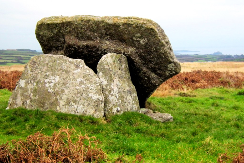
Mulfra Quoit, with St Michael’s Mount behind. I think Mulfra Quoit and Zennor Quoit were both intentionally decommissioned.
This year I wish to bring this work to completion so that I can drop it and pass it on, while I can. It’s not just about completing a body of work. It’s about resolving something inside myself. With others like me, I’ve lived in a time where people like us are not believed – the tide of convention and groupthink has gone the other way. When I was young I knew it would take time but I believed that, by the end of my life, the tide would have turned. Astrology would be accepted, geomancers respected, healers would be accepted as a mainstream medical option, war would be going or gone, the world would be changing and oddbods like me would be seen and heard. This hasn’t happened, so completion now involves leaving clues for others to pick up in future.
For me, it’s also about resolving and healing personal pain. The pain of having ideas rejected because they don’t fit with the prevailing ideology of our time. Things aren’t properly discussed or peer-reviewed, people like me get rubbished, discredited, sidelined, we don’t get the grants and we’re kept off the BBC. Being a vegetarian, meditatator, aged hippy, astrologer, crop circle researcher, social healer and Palestine activist has not been popular with the mainstream. Some things I’ve done have even been illegal – talking to terrorists, delivering babies or using mind medicines – and it is disgraceful that these are still considered crimes.
The pain of being misjudged and discriminated against is a big learning experience for a sensitive soul, and since getting cancer I’ve become more aware of how it has affected me throughout life. I’m working on it by rattling away on my computer, creating an online archive of material which I hope people will find and make use of after I’ve gone.
But it’s a forgiveness process too, because ultimately the weight of unforgiveness rests most heavily on our own shoulders. Time is a healer, and what goes around, comes around. To quote Bhavabhuti, an Indian mathematician and philosopher of the 700s CE: “If learned critics do deride my work, then let them. Not for them I wrought. One day a soul shall live to share my thought, for time is endless and the world is wide.” Until he came along, in mathematics the number Zero did not exist.
I’m up on Botrea Barrows in West Penwith, Cornwall, recounting why they’re there, and what life was like 5,500-3,500 years ago in the megalithic era, in the neolithic and bronze ages, when they were built.
St Michael’s Mount
It’s also about the reasons why the ancient people of Britain went to so much trouble to build sites like this.
They weren’t fools, and they did it to create practical benefits, and they were onto something that is relevant to our day.
It has something to do with building a sustainable civilisation – one that works more or less in harmony with nature. Although it did come to an end, megalithic bronze age civilisation lasted around 1,200 years – pretty good.
Cape Cornwall
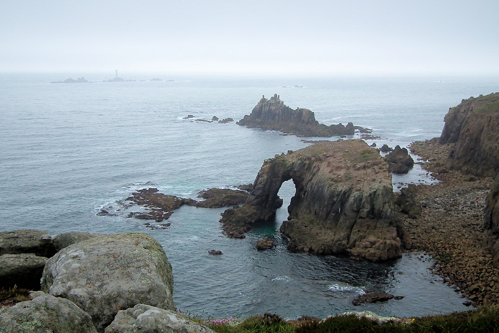
Introduced by a Cornish chough and outroduced by oystercatchers and a raven, and the Atlantic waves at Carn Les Boel, a cliff sanctuary just south of Land’s End, at the furthest end of Cornwall.
This being Britain, as soon as the tourists went home, the sun came out. It seems to be a law of British meteorology. My wooden cabin, with its big windows, gets quite hot when it’s sunny. I sat outside today, soaking it up. One of the very best cancer medicines is sunshine – and it’s free. I need to rest, because I’m shagged out – my legs in particular. Yesterday – pat me on the back, please – I did it. And it well and truly did me.
View from near Pordenack Point
A friend, Kellie, came round and we did the hike from Land’s End to Carn Lês Boel [map here]. For me this was rather special – a personal pilgrimage to a special place. It’s the place where, if I could, I would dance my last dance. I go there whenever I need to say prayers and come home to my soul.
But it’s a long haul, for me in my condition – my walking sticks, serving as legs three and four, get tired too. It’s two miles each way, with a lot of up and down, but it feels like four. I was not at all sure I would make it, but part of me realised that this was my last chance – now or never. There’s a shorter route from Porthgwarra, but this route is special, and I wanted to do it while I could.
Pordenack Point (see the people on top?)
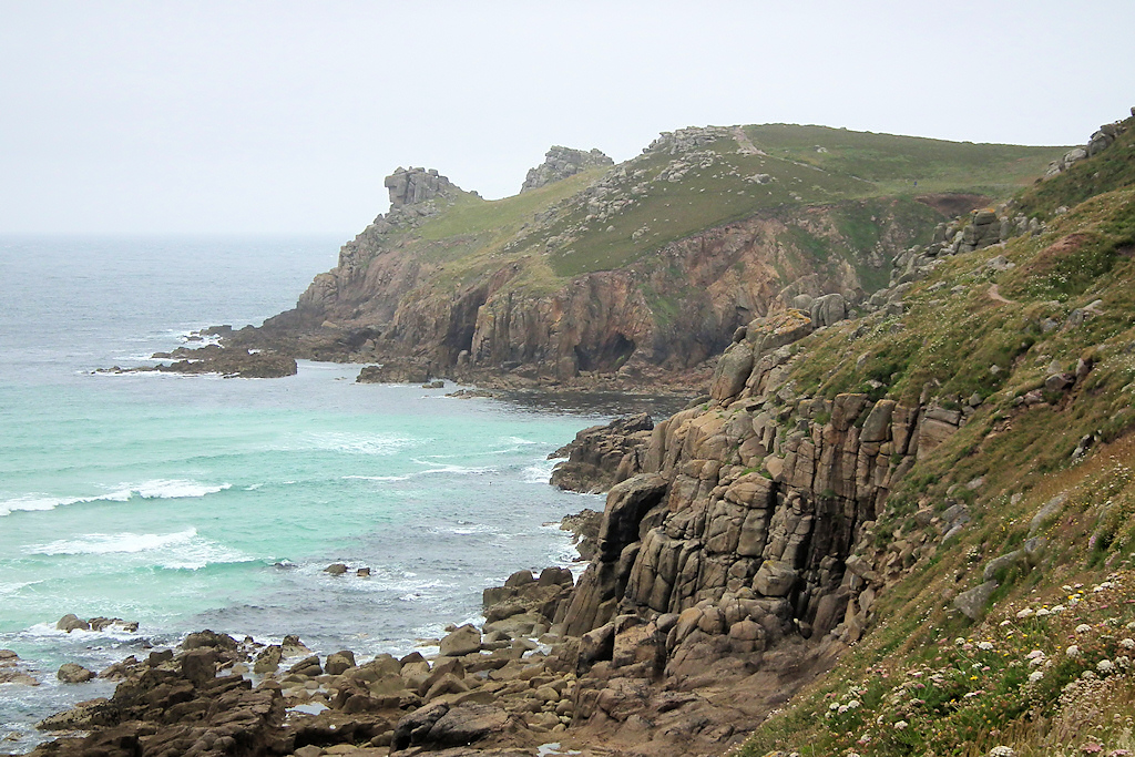
Heading south from the car park at Land’s End, first you come to Pordenack Point, a high cliff bastion which, from the first time I went there fourteen years ago, I knew to be a major clifftop sacred site. But back then there was little evidence of that – to local archaeologists it was just one more of Palden’s crazy, rather left-field ideas. That evidence has appeared since then. It’s a friendly, strangely homely place where you can sense happy gatherings, unions and reunions, even choral singing. The panorama over the sea is spectacular.
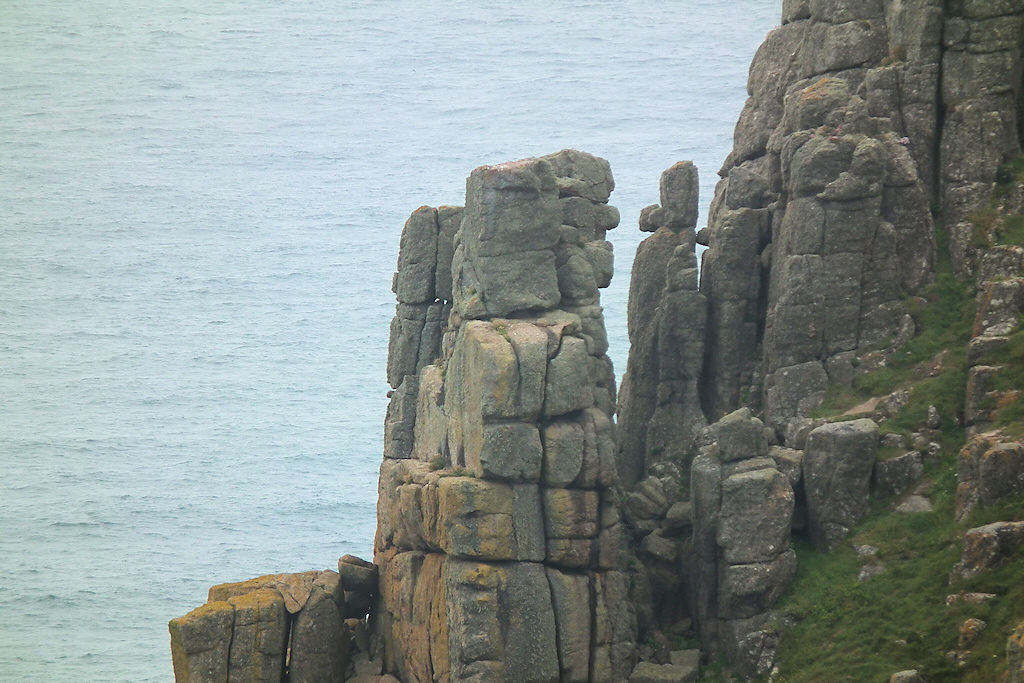
One of the simulacra at Pordenack Point
Pordenack has a prominently-placed chambered cairn, which would have been used 4,000 years ago as an initiatory chamber for deep retreats in this definitely cosmickle place. Also it would probably have been used for dying – it’s a great place for disincarnation, an esoteric spaceport for soul-takeoff toward the Western Heaven. Or it would have been a repository for relics and revered personages put there, at least for a while, to bless the landscape – rather like charismatic saints’ relics in medieval times.
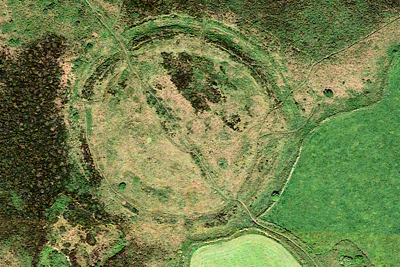
The new discovery was that of a circular enclosure at Pordenack Point, perched on the edge of a near-vertical cliff. That changed things. It was found using LIDAR, a brilliant new form of aerial radar mapping that can pick up hidden remains under the earth’s surface.
Here comes the interesting bit: the enclosure is lined up exactly with two other circular enclosures inland – Castle an Dinas and Caer Brân (pronounced ‘Care Brain’). Both of these enclosures are large enough to host gatherings of a few hundred people, though at Pordenack the enclosure might hold twentyish people. These were all concerned with the coming together of people.
By my reckoning, Caer Brân – it’s just over the valley from the farm where I live – was the parliament and moot site for the tribes of Penwith in the bronze and iron ages. Archaeologists are far more cagey. It is right at the centre of the peninsula, at the intersection of two major trackways. One goes west-east from Sennen (for the Scillies) to Madron and upcountry, and the other, NE-SW, links all of Penwith’s stone circles, from the Nine Maidens and Tregeseal to Boscawen-ûn and the Merry Maidens. This trackway goes past four bronze age platform barrows at the top of Botrea Hill on our farm and over the valley to Caer Brân – I made a podcast about this trackway two years ago.
Castle an Dinas was a further gathering site further east, probably for the meetings of tin traders and for fairs and celebrations at Beltane and Lammas. This is deduced from two astronomical alignments emanating from the enclosure, aligned to the rising and setting points of the sun at those times – the sun rises over Trencrom Hill and sets over Conquer Cairn.
Caer Bran
My feeling is that Caer Brân was rather more for formal and jurisdictional assemblies, while Castle an Dinas was more of a marketplace and social gathering site. Just up the hill from Caer Brân is Bartinney Castle, a hilltop circular enclosure with cairns inside it, which has a distinctly spiritual-religious character and a remarkable panorama. Legend has it that the Devil can never get at you inside the enclosure on Bartinney.
But, get this, three of these circular enclosures – Pordenack, Caer Brân and Castle an Dinas – are exactly aligned along a summer solstice sunrise orientation. Gatherings and festivals were really important to ancient peoples, and the people of the tribes of Penwith would come together at these enclosures at special times of the year.
In those days, folks weren’t as peopled-out and time-pressed as we are – there weren’t so many people around and, if you went anywhere, you walked. Much of the land was wooded, which gives a different space-perception to the open farmed landscapes we’re used to nowadays. Jumping in the car to visit friends wasn’t an option, so you met with them periodically, when you could, at gatherings like these, particularly at the solstices and cross-quarters.
You’d meet your relatives, distant friends, old acquaintances and new people too – at Castle an Dinas there would be interesting people from abroad, even in ancient times. There would be discussions, decisions, the making of deals and the settling of disputes. There would be trading, flirting, celebration, partying and morning-after hanging out, with moments of invocation, spectacle and holiness. They’d troop there from their living places around the peninsula, stay for 2-3 nights and troop back home again.
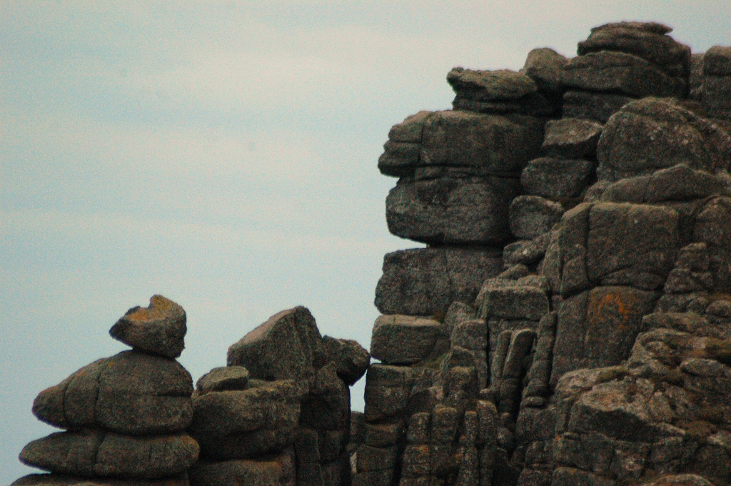
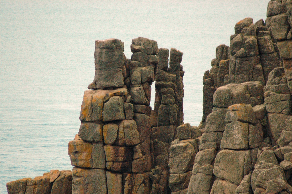
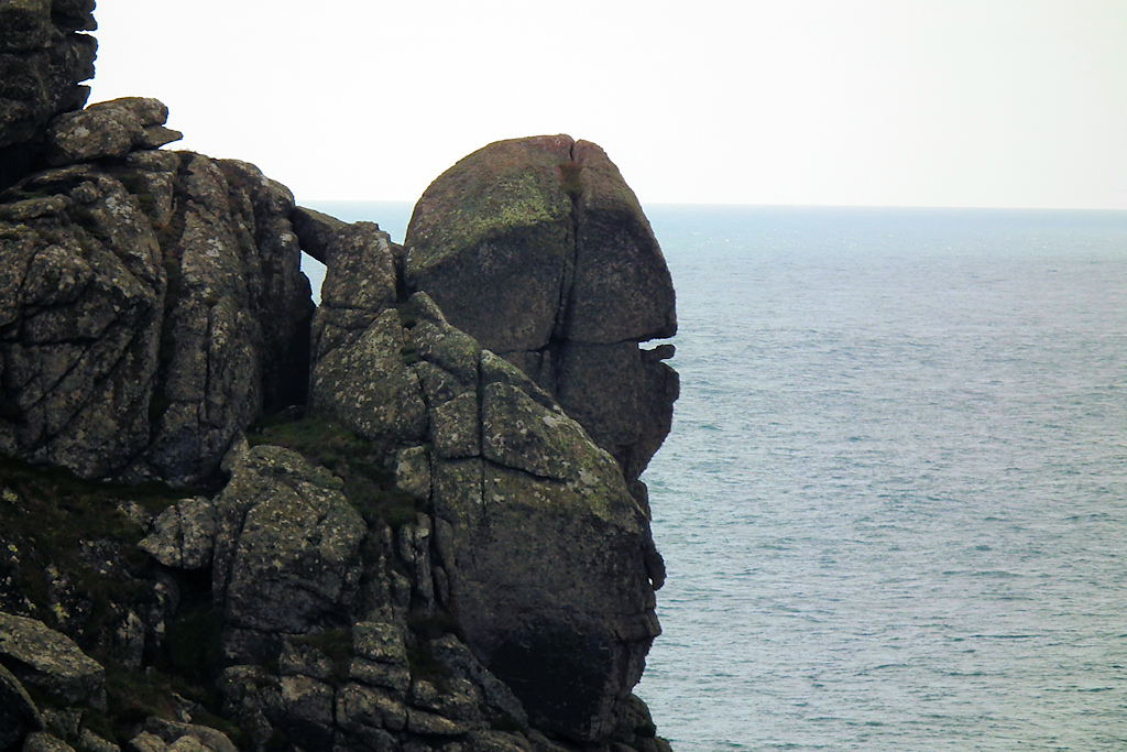
Pordenack Point is special not just for the above reasons. It hosts what must be one of the world’s largest collections of rock simulacra – natural rock shapes resembling ancient beings. There are whole gaggles and convocations of them – guardian rock-beings who face the vastness of the Atlantic at the far end of the Isles of Britain, holding the winds and waves at bay and protecting these isles from the storms, currents and weather gods. Some of the simulacra stand there chatting, and some are watchers, peering toward the far horizon. Some are Keepers of the Law, some are the Chanters of Intonations, and some are grumbly earth beings who resent the dwarvish bane they carry.
Carn Boel
Then you head onwards to Carn Boel, the next headland along the coast. Carn Boel (‘headland of the axe’) and Carn Lês Boel (‘headland of the court of the axe’) form the bounding headlands of Porth Nanjizal (Nanjizal Bay, pronounced ‘Nanjizzle’). Carn Boel has a big outcrop with a hooked nose, on top of which is a rather magical stone and sitting place, looking out to sea. Perhaps a place for consulting ancient seers and soothsayers.
Then you follow a cliffside path – a bit challenging if you have vertigo – alongside Porth Nanjizal, past a fascinating granite outcrop called Carn Cravah. We had a good sit and a round of tea there – I was already having to pace myself because, since I got cancer four years ago, I have few energy reserves to draw on. So it’s an exercise in prana-management, energy-management, pushing myself but not pushing too much. Often there are seals hanging out in the water below, but they weren’t around yesterday, possibly because of all the humans frolicking happily in the water.
Nanjizal Bay
Then you get to Nanjizal, a lovely sandy cove. It lost all its sand in the storms of 2014, but the sand has returned now. It was quite busy. It was lovely to see children getting lost in the magic of the place and playing in the waves, without a care. At least half of the people present seemed to have foreign accents – central Europeans, accustomed to being landlocked, love Cornwall and its wide-open, oceanic coastline. Since Covid we’ve had a new wave of non-white, second-generation Brits coming to Cornwall, laying claim to the extremities of their homeland, to plant their hearts in the landscape and tune in to its roots, and I really like that – they’re welcome.
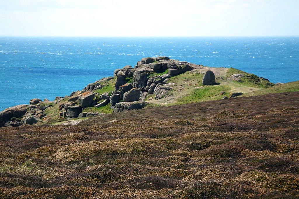
Then it’s a steep climb up endless steps to the top of Carn Lês Boel, a few hundred feet above the sea. This was a killer and I had to take it slowly, step by step, with two pauses and one sit. An old dog came puffing up the steps like a steam engine, gave me some friendly slobber and continuing on its way, followed by a puffing human, smiling as he passed at this old hippy sat there in his Arabic jalabiya.
The path onto the carn is on the right of the propped menhir
But I got up there. It was painful, but the Carn makes the price worth paying. Its energy-field is strong and uplifting. It’s a place of transformation and healing, with a lightening (levitational) and enlightening (uplifting) effect. You can feel it as you approach. There’s an ancient ditch crossing the neck of the Carn, marking the boundary of its sacred space – I stop there to ask permission to enter but the answer is always ‘Yes, welcome back‘.
The propped menhir
Then there’s a gateway marked by two menhirs, one now fallen. At times, before cancer, I had a sneaky urge to come here one night with a few friends to re-erect it, but it never happened. The other gateway stone is a rare propped, crystalline granite menhir – raised up on small stones so that there’s a gap underneath, so that the menhir doesn’t itself touch the ground. The purpose of this is difficult to tell, but there’s quite a concentrated energy-field in the gap underneath. A similar thing happens at two other such stones: one at Trevean, half a mile away and probably built by the same builders at the same time, and the other a few miles up the coast at Carn Creis, amongst the Boscregan Cairns.
At the top of the carn is a rock platform with an energy-vortex that makes my body sway involuntarily when I stand on it. A nearby tipped-over stone probably stood on this vortex in former days. There’s another energy-centre further along the carn – a natural rock pile with a vortex emerging from the top – and, yesterday, over this and the first energy centre there were swarms of flying ants, swirling around psychedelically in the heat, following the flow of the energy-vortices.
When I’m there I settle and eventually lie down, finding myself drawn deep inside the carn. Esoterically it feels hollow. It does have seal caves in it, but this is a different kind of hollowness, as if there is an enormous atrium of vastness and voidness underneath, Tardis-like and bigger than the already enormous carn itself. There’s a feeling of very ancient beings here – geological beings who were here long before humans were ever thought of. There’s also a wide-open, upwards-and-outwards, infinite-space feeling to the carn, with its oceanic vista. The next stop across the ocean, thousands of miles away, is the Yucatán peninsula in Mexico, the Mayalands.
Carn Lês Boel marks the western end of the Michael Line, a line stretching across southern Britain along its widest axis, crossing Glastonbury Tor, Avebury and other major sites along the way. That’s one reason why this site seems to me to be working at a higher level than many other sites around Penwith – the carn is on a global great circle energy-line.
I needed to come here because I feel I’m at a junction point. I’m drawing a blank on where the roads lead from here. Unusually for me, at present I see no future – no sense of where I’m going or what happens next, or even what I want or need. I’m not sure how to interpret this, but I see three possibilities. One is that I’m just plain blank and need to feel alright about that. One is that I am on the edge of something, a new chapter, the form of which I should not even try to pin down at this stage, in order to allow it the space and freedom to develop. Or the third possibility is that my life might end quite soon, and that I see no future in life because there isn’t one – the path leads through a threshold to another, less physical world.
I can accept any of these, for although I turn 73 on my birthday (Tuesday 5th September), and I’m not that old, I feel like a hundred years. Life has been an uphill grind in recent years and I feel rather worn out. Tired of pushing hard to get through life, tired of all the palaver and complexity. But I’m not set on that either. I’ll be wherever it is most useful for me to be.
I’m rather a mission-driven kind of chap, and if there is something meaningful and manageable for me to do here on Earth, then I’m up for it. But my life has developed a kind of emptiness. I miss my family, my partner and her family. In the wider world I am well liked but not greatly included. Regarding will-to-live, it does make a difference when there’s someone to live for, and perhaps I haven’t appreciated this sufficiently, earlier in life. I’m not good at doing nothing, staying alive just to stay alive, and I’m uninterested in watching TV, entertaining myself, feeding my face and living in glorious isolation. There’s more to life than this, and if there isn’t, then perhaps I’ll be better off going back home.
That’s why I went to Carn Lês Boel, to place myself before the Vastness, to make a ‘here I stand‘ life-statement, to ask a question and make a prayer. I chose the hard path to get there since it might be the last time I can do that route. It’s special to me because, this time in particular, I have to work at it, wear myself out, and that’s a quality that pilgrimages need to have. I needed to open myself up to whatever is to come. To ask for clues.
I didn’t get anything definite for an answer except for one thing: when leaving the carn I paused and asked, “Is this my last visit?” and the answer was definitely ‘No’. That perked me up. But instead of giving answers, this pilgrimage brought a change in me, a change of state. The questions started mattering less, and I came to a feeling that everything is alright, okay and perfectly in order.
Even so, I had to build myself up for getting back. Part of me didn’t want to leave. Another part of me knew that I had to start now, while I still had energy and before my body stiffened too much. Being on the carn had recharged and reconditioned me, and I knew I just had to apply mountaineer’s grittiness, persevering through the next bit to get myself home – well, back to Kellie’s car.
So I psyched myself up and went for it. My legs and back were hurting and my strength wasn’t great, but I just had to do it. At times like this, when I’m out in the wilds, I have a secret wish my dear son would winch me up into one of his helicopters and teleport me back to the farm. But this is Planet Earth, and he’s busy with other things.
This said, the whole trip was really worth it. Kellie was great company too – a right-on lady who’d been a road campaigner in the 1990s and who, I sense, stands on the edge of taking on a new mission of her own sometime soon. She’s one of those women whose kids are hitting twenty, who finds herself standing in front of a rather big, wide-open space. She was attentive to my needs, pace and timings, which was great, but she didn’t fuss over me, letting me stagger along at my own pace – and this old cripple likes that! She also seemed to like the Queen Mary’s Rose Garden tea that I brought in a flask. And I liked the lunch she had brought, which we had at Nanjizal Bay, just before climbing up to the carn. Thanks, Kellie – and I hope the trip was auspicious for you too.
Another person who came along, in spirit, was the Okomfo Akue Ayensuwaa – a new soul-sister I’ve never met, and queen priestess of the Ayensu River in the Gold Coast of West Africa. We have worked together on a shared mission for the last nine months and, while Kellie and I were doing this pilgrimage, Maa Ayensuwaa was at her shrine, accompanying us in spirit. This lady is deep, and if she so chooses she really is with you. There’s a Nepali seer who has also entered the equation, and we form a sparky triangle. I’ll tell you more about this and our story another time, when it’s safe and proper to do so.
Today, on the day following our walk, my legs ache, and I’m happy. Sometimes I have a question but it turns out that I don’t really need an answer. Sometimes it’s just a matter of changing my state. Something is reintegrating. What I love about visiting a power point like Carn Lês Boel is that it can transport me out of the confines and coordinates of my life and raise me to another level. I get more of a panoramic sense of life – a sense of context and meaning that seems to slot everything into place. It’s a shift of viewpoint that casts another light on things so that they look different – and this in turn leads to different outcomes.
On this walk something else came clear. There are advantages to being aged, especially if I accept it fully and completely. There’s no longer a need to hurry. It isn’t a time of goal-orientation but a time of allowing. The urge to get there, to achieve objectives, and to get on with the next thing, fades into the past – almost as if it was another life. As my physical powers have declined, my psyche has become more spacious since I’ve been obliged to drop many of the concerns, activities and preoccupations that used to fill it. It means that, with an undertaking such as walking to the Carn, I can take each stage, each footstep, as it comes. I just keep on going, step by step, neither pushing nor giving up, and I keep on going until, suddenly, I surprise myself by finding I’ve actually got there.
Life is nowadays more of a here-and-now thing – not least because the past is fading in memory, and there isn’t a lot of future ahead, and when I spend a lot of time alone, other people aren’t around me, keeping me attuned to the issues, struggles and woes they face. So I lose track of most people’s sense of reality, floating off in my own bubble. That makes the present time expand into more of a timeless zone. It has a beatific effect, adding an enlivening sparkle to life, giving a rather childlike sense of spontaneous discovery of every moment. The urge to get there, to reach the destination, to tick off everything on the list, is a compulsion that touches me much less than ever before.
Yet again, Carn Lês Boel gave a gift of time, out of time. At life’s junction-points it’s a good place to go, as if to clock in to the universe to renew my contract with the Great Wide and Wonderful, to go through a reassessment turnstile, to get worked over by the spirits of the ocean and vibrational field of this holy cliff sanctuary.
So that’s what I did on Saturday.
Lots of love from me, Palden
The photos here were taken on earlier trips – I wasn’t in a photographic mood yesterday.
Godrevy Head and Lighthouse from St Ives, Cornwall, with St Agnes Beacon behind
Here’s one of my podtalks, recorded in early August, Lughnasa, at the Oak Dragon Camp in Somerset.
It’s all about our prehistory in Britain, and how and why people built ancient sites, and their advanced shamanic-magical culture, and sympathetic, sustainable societies, and the creation of gods and religion, and a few other wee matters such as these.
A sweep over the megalithic periods of the Neolithic and Bronze ages. 90 mins.
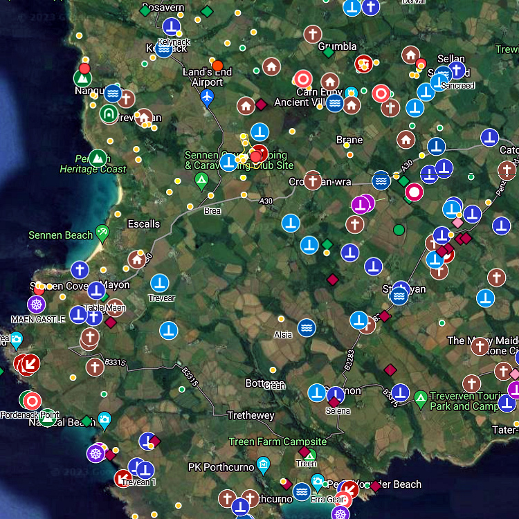
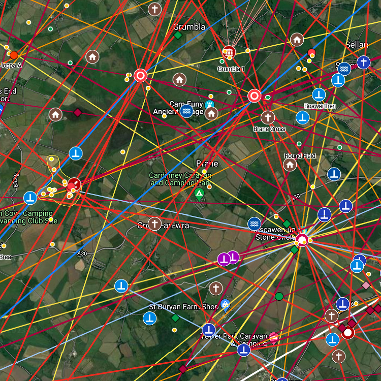
If you’re resident in Cornwall or a Cornwall fan, or you’re likely to visit here this year, and if you’re into visiting ancient sites, these maps are useful.
The last five days, since it has been rainy a lot and quite often really white-out foggy, I’ve been doing my six-monthly updates of the ancient maps of Cornish and Scillonian ancient sites that I’ve been working on since 2015.
There are two main maps: 1. ancient sites 2. ancient site alignments
These are not just maps but also rather encyclopaedic databases. That is, if you click on an ancient site symbol, a popup give you information and links to other sites where there’s more info about that site.
The location of ancient sites is very accurate and these maps can be used in the field, so that you can find sites when tramping around.
However, before entering ancient sites, please switch your phone off completely, so that you don’t pollute the site and you feel and experience the site more clearly.
If you live in Cornwall or are visiting this summer, or if you’re a fan of Cornwall, these maps are very useful!


You must be logged in to post a comment.