
One of the strange gifts that cancer gives is the prospect of dying soon. It’s is a motivator. You can’t leave things till later or leave them incomplete. So I’ve been moved to bring things to completion as much as I can – with success in some areas and less in others. One area I’m focusing on wrapping up now is my study of the Megalithic period of the Neolithic and Bronze Ages.
For the last ten years I’ve been researching ancient sites in West Penwith, where I live, drawing on fifty years of study and experiences in Britain, Scandinavia, Greece, Jordan and Palestine. Having done an alignments map of Glastonbury twenty years ago,[1] in 2014 I started making a map of the ancient sites and alignments in Penwith.[2]
West Penwith, the shining land of Belerion, has more ancient sites per square mile than anywhere in Europe. It’s the far promontory at the very end of the long southwestern peninsula of Britain. Surrounded by cliffs on three sides, it has a distinct energy-boundary on the landward, eastern side, made up of three hills lying in a straight line – St Michael’s Mount, Trencrom Hill and St Ives’ Head. On the A30 to Penzance it crosses the road by the shop in the village of Crowlas.
Alignments in Penwith have been studied over the decades by John Michell and a number of other researchers. John wrote the 1974 book ‘The Old Stones of Land’s End’, identifying around ninety alignments involving mainly Bronze Age and early Christian sites. Checking these alignments with online satellite mapping, not available in John’s day, I found that only two of the ninety were inaccurate and questionable.

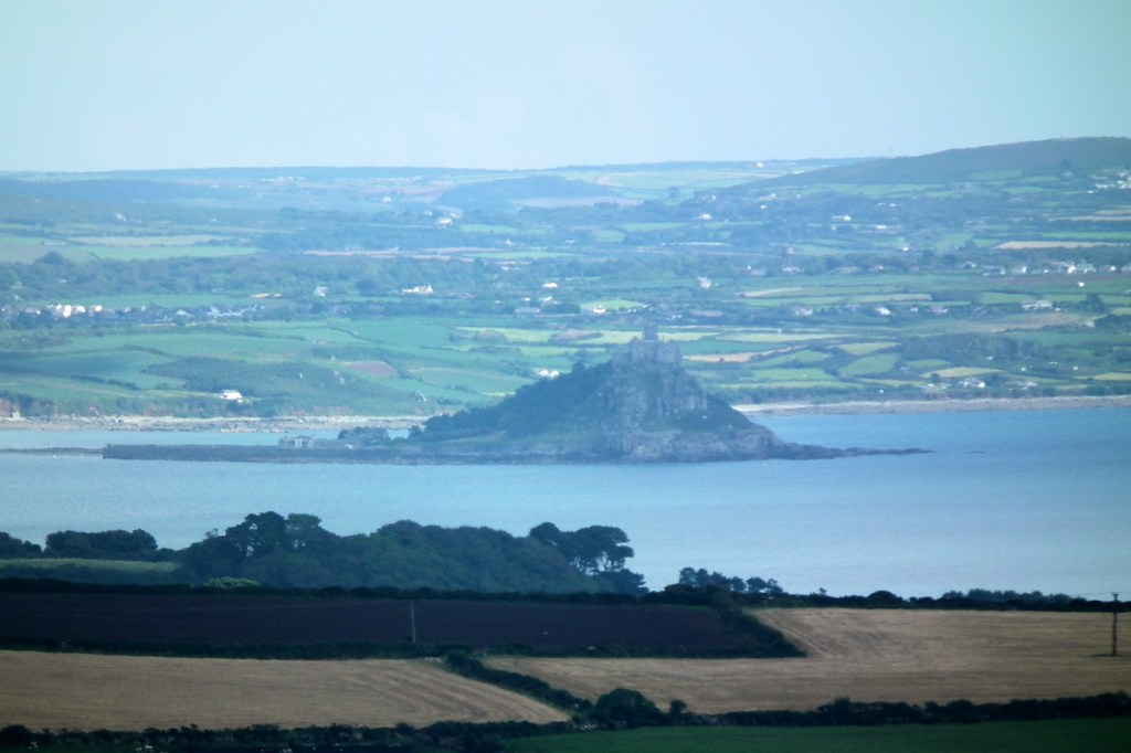
Then late one night came a Eureka moment, after an evening working on the Penwith map. I was tired yet unready to go to bed. I sat there musing about St Michael’s Mount, a roughly conical hill in a marine setting, and then about Cape Cornwall, a prominent headland near me, with a similar character. Both were prominent ancient sites on either side of the peninsula.
Spontaneously I got out a ruler, placing it between the two sites to see if an alignment was there. Lo behold, indeed there was. It passed through a set a four barrows up on the top of the hill on our farm, not far from my house. Gosh, that was a surprise.

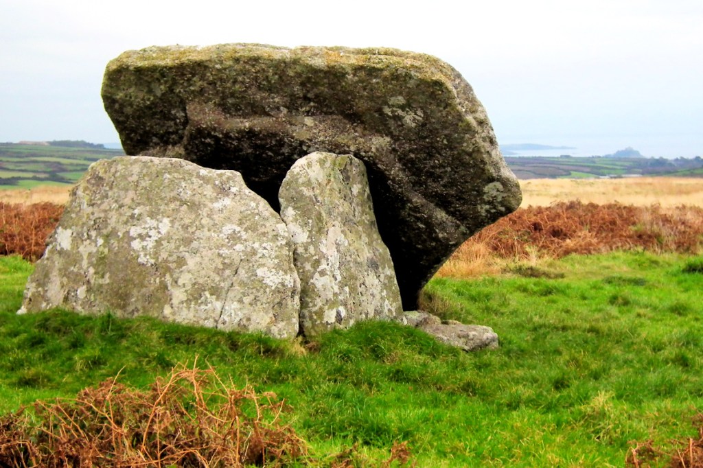
I spend a lot of time up at Botrea Barrows and, though they don’t look impressive, they have a remarkable panorama and they certainly have that distinct feeling you get at an ancient site that is still energy-alive. It’s a feeling of being changed in mood and perspective, energy-bathed, both calmed and energised.[3]
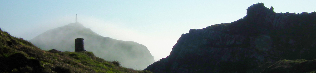
A lightbulb lit up. I started checking to see whether there were further alignments like this. The Mount and Cape Cornwall are both cliff sanctuaries. They form a necklace of magic headlands around Penwith, and also much of Cornwall and parts of Devon (there’s a big one in Somerset called Brean Down). So I started checking other cliff sanctuaries and suddenly a lot of new alignments appeared. Normally called cliff castles, they aren’t defensive, and they’re not just beautiful places but also they have a special feeling of being consecrated, so I call them cliff sanctuaries.
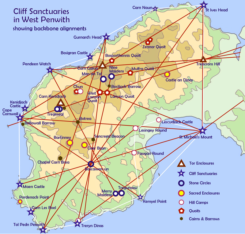
I found about eight alignments in twenty minutes – a record never again repeated, since usually they don’t come easily. Not only this, but many of the alignments connected with Neolithic tors, the very first dedicated ancient sites in Penwith, Cornwall and Dartmoor. There are five in this area: Carn Brea, the Mount, Trencrom Hill, Carn Kenidjack and Carn Galva.
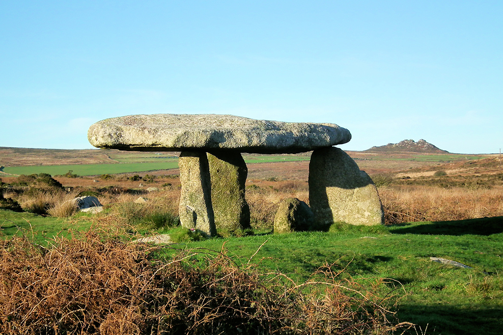
Something interesting emerged. Three of these newfound alignments crossed exactly at Lanyon Quoit. One came from Carn Brea near Redruth (a Neolithic tor), through Trencrom Hill (a Neolithic tor), Mulfra Quoit and Lanyon Quoit (Neolithic quoits or cromlechs). It continues to the Tregeseal stone circle complex and eventually to the Brisons Rocks off Cape Cornwall. This implies that, when it was built in the Bronze Age, Tregeseal was deliberately placed on this alignment, or that the site was known in the Neolithic even if it took a millennium to build a stone circle on it.
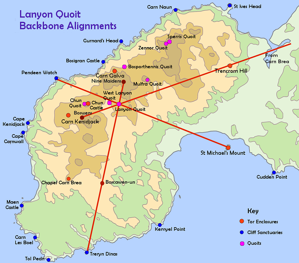
Another alignment went from St Michael’s Mount (a Neolithic tor) through Lanyon Quoit to Pendeen Watch (a cliff sanctuary). A third alignment went from Treryn Dinas (a cliff sanctuary) through Boscawen-ûn stone circle and Lanyon Quoit to Bosiliack Barrow and a proxy menhir at the Nine Maidens stone circle. Thus, the location of stone circles is significantly determined by these alignments (though multiple interlocking factors are usually involved).
That sounds straightforward, but the implications are quite big.
Lanyon Quoit was built around 3700-3500 BCE, as were the enclosures built to encircle the Neolithic tors. Since the quoit’s precise position is fixed by these three alignments, each aligning with tors or cliff sanctuaries, it means that cliff sanctuaries date back in their first us to at least that time. In one fell swoop, the number of Neolithic sites in Penwith doubled.
Cliff sanctuaries are not usually regarded as major ancient sites.[4] This discovery changes that. Archaeologists ascribe them to the Iron Age around 2,500-2,000 years ago. But we now have geomantic evidence that they were far older in first use and far more important. They were consecrated – you can feel this when you visit them, since they don’t have the same feeling as other headlands. To test this, visit Zennor Head, an ordinary headland, and then neighbouring Bosigran Castle and Gurnard’s Head, both cliff sanctuaries. They’re special. The discovery of Neolithic archaeological remains at some of them hasn’t caused archaeologists to drop their attachment to Iron Age fortresses though.
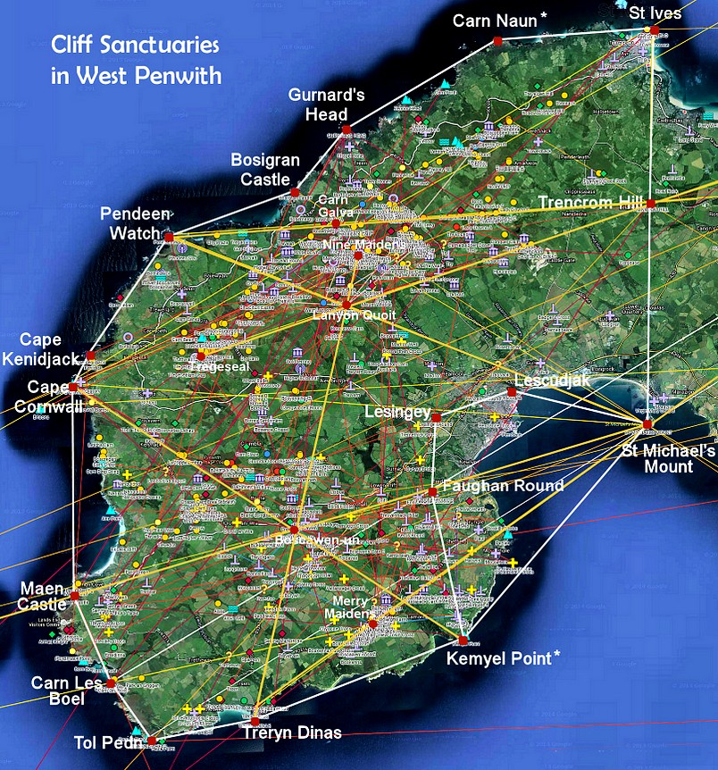
These new alignments I call ‘backbone alignments’. They are different from the alignments John Michell and most ley-hunters studied, involving Bronze Age sites such as stone circles, cairns and menhirs. In Penwith, what’s special about the backbones is that they represent a more coherent order than the Bronze Age alignments. I’m surprised no one has discovered them before.
More implications… The backbones reveal a coherent structure to the 600 ancient sites of West Penwith. They hint at a master plan – a plan to make Penwith into one big landscape temple, one big cliff sanctuary. This idea hasn’t caught on down here, except with one archaeologist (David Giddings) who struck upon it independently, using a different logic and terminology from me.
We aren’t looking at a random collection of ancient sites splattered across Penwith wherever anyone fancied. We’re looking at a planned, integrated network and system of ancient sites.
It evolved according to basic protocols but not a rigid plan. Here’s an analogy. The Internet was not planned, and what has emerged in recent decades is not what was foreseen and intended early on. However, it evolved according to consistent protocols – a bundle of coding that operates internet networks in a coherent, expandable, adaptable way. Although it grew organically, there was system to it.
Similar applies to the principles established in the Neolithic 3000s – principles first developed in Iberia and brought to Britain around 3700 BCE with a wave of incoming migrants at that time. (They spoke a language related to Basque.) Later, in the Early-to-Mid Bronze Age (2500ish to 1200ish) the Brits took these principles further than anyone, to high degrees of astronomical, mathematical, geomantic and cosmological sophistication.
According to Knight and Lomas [1] even the Egyptians are likely to have learned some mathematical tricks from the Brits concerning the curvature and size of the Earth and the precession of the equinoxes. The Bronzies were doing Pythagorean and Euclidean mathematics two millennia before Pythagoras and Euclid, and they understood the astronomical Metonic cycle two millennia before Meton, another Greek philosopher, wrote it down and got the kudos for it.
This gets bigger when we look at the reasons why the megalith-builders went to so much trouble building megaliths. Here we go right outside the scope and beliefs of archaeologists into the wilder territory of geomancers. When the Neolithics and Bronzies built ancient sites, they plugged them into astronomical variables, underground water, networks of energy-lines, networks of alignments (those are two different things), and they built them using advanced mathematical and astronomical systems. They locked time into space through the designs, orientations, proportions and alignments of ancient sites, particularly stone circles, the ‘cathedrals of the Bronze Age’. Why?

Well, go to an ancient site and spend time there. You’re entering a multidimensional energy field. The evidence lies in observing our feelings, registering those feelings and taking them seriously. The depth and significance of experience is magnified at ancient sites. When you leave, it’s worth noting what’s different in your state, mood and optic. It’s far more than the uplift you might gain from a walk in the countryside. Test it out.
The character and feeling of this experience depends on several factors, contingent on the time you visit, your motivation and respect, how openly you and the place interact with one another, how the place itself is feeling at the time, what you do, what you don’t do, and also there’s a mysterious ‘factor X’, a magical concatenation of conditions that makes some visits extra memorable, even transformative. These variables influence the character of our experience of ancient sites when we visit them – and their experience of us.
This is a consciousness effect. We don’t understand how it works, but it does, and there are hints of proof in neuroscience and parapsychological research. You don’t have to take my word for it: simply visit ancient sites and try it for yourself. The principle here is that containing, fixing and enhancing energy fields seems to be the key reason why ancient sites were built, and why they were placed and designed as they were. This was a technology of consciousness.
It isn’t difficult to feel or sense subtle energy, at least instinctually or semi-consciously. If you’re capable of feeling love, you’re capable of feeling energy, and this is a capability we are born with. But it is more difficult to square this with our overlaid, educated rationality which, together with fears, conditioning, insecurities and emotional armouring, tends to edit, dull, obstruct, corrupt or suppress our sensitivities.
To many people, what I’ve written about consciousness effects makes little or no sense – it’s imagination, woo-woo and hocus-pocus. ‘No evidence’ – though actually, there is. Academics and archaeologists are missing something really big here.

The consciousness effect was valued because these people worked magically – shamanically. This matter lay at the heart of their culture. They worked with the inner components of reality, knowing that what happens within us is entirely connected with what happens around us (called non-dualism). Ancient sites of different kinds were built to exploit various opportunities of consciousness.
Some sites train our awareness upwards, some out to the landscape, some to the earth-sky relationship, some downwards (such as wells) and some inwards (such as chambered cairns and fogous). Stone circles, the reactors, telescopes and laboratories of megalithic times, create a palpable and measurable energy-intensity within their enclosed space.
This would be used at auspicious times for high-pressure magical-ceremonial workings. A few hundred people would surround the circle, fasting, chanting, dancing and visualising, probably with the help of mind medicines, while inside it ‘proto-Druids’ would perform the specifics of the work. They did this to create an intensified energy-field to perform healings, balance the etheric bioelectronics of land and sky (affecting fertility and climate), carry out ceremonial consciousness work in connection with the environment and the welfare of the people, make decisions through an oracle, communicate over long distances, protect the land and keep the spirits of land and sky happy.
But this is not all, since West Penwith is one big ancient site made up of hills, tors and headlands, stone circles, menhirs, cairns and barrows, quoits, enclosures, holy wells and other sacred spaces. These represent a significant buildup of geomantic infrastructure designed around the landscape itself, using subtle energy technologies. It took until the peak of the Bronze Age around 2000-1800 BCE for the infrastructure to take full shape.
However there are signs of a trial run in the Neolithic 3000s in the northern highlands of the peninsula, where most people then lived: the quoits were arranged in a structure involving astronomical and parallel alignments, suggesting that the quoits were built to a coordinated plan. They might all have been built around the same time.[5]

Recently I’ve been studying landscape temples in Penwith. These are areas that hang together in terms of the psycho-geographical, perceptual and magical lie of the land and its features. It is likely that these roughly coincided with the social subgroups or tribes of Penwith. Everyone was related somehow, but social subgroups occupied certain areas, calling them ‘home’. These were not days of territorial frictions, and what mattered most was heartlands more than boundaries.
Based on my knowledge of the area, I’ve drawn a map of what I think those landscape temples and tribal areas might be, as they might have been seen in the Bronze Age, around its zenith. It is hypothetical with little backup, but it’s an interesting thought-experiment and it makes some sense in terms of the lie of the land and the way ancient sites are arrayed.

Here’s an example. On the west coast of Penwith, between Mayon Cliff near Sennen in the south and Cape Kenidjack in the north, a landscape temple is marked out by a series of clifftop cairns.[6] They all face the sea, toward the setting sun and the Isles of Scilly, with the Longships Rocks and Chapel Carn Brea acting as focal points of attention. From every one of these cairns you can see Chapel Carn Brea, the first and last hill in Britain – it has a Neolithic longbarrow and Bronze Age cairns on top. Sennen was the main landing beach for Scilly boats, and the people of this area will have been involved with Scillonians and probably related to them.

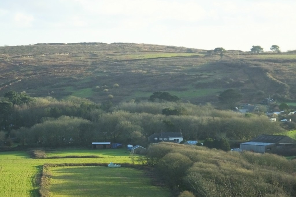
I live in another landscape temple made of four hill sites and a valley between them, at the centre of the peninsula. Bartinney Castle is a high, convex, rounded hill with a circular enclosure, eight cairns and a well on top, probably used for quite high-level magical purposes. Caer Brân is a circular enclosure on a hillbrow with a remarkable panorama – I think it was the parliament site for the whole of Penwith and, within its magic circle, a neutral space. Sancreed Beacon feels to me as if it was a ceremonial centre and seat of power for the local tribe. Botrea Hill has four large platform barrows on it, likely to have been used for ceremonial-magical purposes. All four hills are within view of each other, part of the same perceptual landscape and complementing each other in character.[7]
Penwith was one large landscape temple with a variety of localised areas within it, each with its own character and geomantic facility.
Gradually I’ve been building a picture of life in Penwith in the Neolithic 3000s and the Bronze Age. These periods were quite different, not least in population numbers, which were much bigger in the Bronze Age. But what many people miss is the esoteric depth of the culture of the megalithic period. The bottom-line issue is that megalithic sites cannot be understood without appreciating the crucial role of subtle earth energy in their construction, location and reason for being.
It’s also important to acknowledge the role of shamanic consciousness work in the way the people of the time managed their affairs. This was a theocratic, magical civilisation and, while it didn’t build cities, roads and empires, its thinking was advanced.
This is not just a captivating fascination with the past: it has something to do with our future and the healing of our world. My work in West Penwith has led me to this.
This year I wish to bring this work to completion so that I can drop it and pass it on, while I can. It’s not just about completing a body of work. It’s about resolving something inside myself. With others like me, I’ve lived in a time where people like us are not believed – the tide of convention and groupthink has gone the other way. When I was young I knew it would take time but I believed that, by the end of my life, the tide would have turned. Astrology would be accepted, geomancers respected, healers would be accepted as a mainstream medical option, war would be going or gone, the world would be changing and oddbods like me would be seen and heard. This hasn’t happened, so completion now involves leaving clues for others to pick up in future.
For me, it’s also about resolving and healing personal pain. The pain of having ideas rejected because they don’t fit with the prevailing ideology of our time. Things aren’t properly discussed or peer-reviewed, people like me get rubbished, discredited, sidelined, we don’t get the grants and we’re kept off the BBC. Being a vegetarian, meditatator, aged hippy, astrologer, crop circle researcher, social healer and Palestine activist has not been popular with the mainstream. Some things I’ve done have even been illegal – talking to terrorists, delivering babies or using mind medicines – and it is disgraceful that these are still considered crimes.
The pain of being misjudged and discriminated against is a big learning experience for a sensitive soul, and since getting cancer I’ve become more aware of how it has affected me throughout life. I’m working on it by rattling away on my computer, creating an online archive of material which I hope people will find and make use of after I’ve gone.
But it’s a forgiveness process too, because ultimately the weight of unforgiveness rests most heavily on our own shoulders. Time is a healer, and what goes around, comes around. To quote Bhavabhuti, an Indian mathematician and philosopher of the 700s CE: “If learned critics do deride my work, then let them. Not for them I wrought. One day a soul shall live to share my thought, for time is endless and the world is wide.” Until he came along, in mathematics the number Zero did not exist.
With love, Palden
–
FOOTNOTES
For a key to symbols used on the online maps: www.ancientpenwith.org/key.html
- Map of the Ancient Landscape around Glastonbury, Gothic Image, 1983 and 2005. www.palden.co.uk/leymap
- Map of the Ancient Sites and Alignments of West Penwith: www.google.co.uk/maps/d/viewer?mid=1rZQT0gYvH9uD_nxg9f4sNByaHQbbBqTw&ll=50.122514747105356%2C-5.6038752366332645&z=12
- Podcasts from Botrea Barrows: www.palden.co.uk/podcasts/PFB03-210613-BotreaBarrows.mp3 and www.palden.co.uk/podcasts/PFB40-BotreaBarrows-230909.mp3
- About cliff sanctuaries: www.ancientpenwith.org/cliffcastles.html
- Online map of quoits: www.google.com/maps/d/viewer?mid=115Hwb1BI-_lmNyQ4bz-gF0dhciU&ll=50.16159288655412%2C-5.593891490692237&z=13
- The Boscregan landscape temple: www.google.co.uk/maps/d/u/0/viewer?mid=10TKtQKR4aFSymGj23xUiYmCBQ1Frnfz5&ll=50.09990259589591%2C-5.670959956329282&z=13
- About sacred enclosures: www.ancientpenwith.org/hillforts.html#SacredEnclosures

